Floods are classified into five major types: flash floods, coastal floods, river (fluvial) floods, ponding (pluvial) floods, and urban floods.
A study in 2019 found that over the last 60 years, many areas in India, especially those in central India, have been experiencing an increase in extreme rainfall events, with corresponding surges in flooding. However, there were no increases in the numbers of severe rainfall events; rather, there has been an increase in the area over which such events occur.
Beyond the broader approaches to mitigate climate change, India needs robust flood management structures which not only involve better disaster mitigation systems in areas prone to repeated flooding, but also better regulation of how floodplains are utilised.
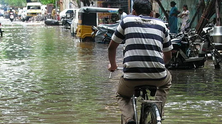
Floods occur when water overflows from water bodies – seas, oceans, ponds, lakes, canals, or rivers – and submerges land which is usually dry. Floods, especially in India, are some of the most common and severe natural weather events that lead to huge losses of life, property, and livelihoods.
According to a study in 2021, floods and cyclones have caused the most numbers of extreme weather-related human deaths in the past 50 years in India. The two together are held responsible for nearly 75% of all mortalities due to extreme weather events per year.
Despite advances in early detection and warning systems and great strides in disaster management, the states of Odisha, Assam, Bihar, Kerala, Andhra Pradesh, and Maharashtra have had huge mortality rates due to extreme weather in the last two decades.
How Does Flooding Happen?
Floods can occur due to different reasons, and are classified into five major types – flash floods, coastal floods, river (fluvial) floods, ponding (pluvial) floods, and urban floods.
Flash floods are fast-moving unexpected floods that occur when there is a surge in flowing water levels such as those caused due to sudden heavy rainfall or an outburst from a glacial lake.
Coastal floods occur when sea levels rise due to heavy storms combined with high tides; this forces seawater onto the normally dry inland areas adjoining the coast. River or fluvial floods usually occur when rivers, swollen with prolonged or extensive rainfall, breach their river banks and flood surrounding areas.
Ponding or pluvial flooding happens in flat areas when prolonged rain overwhelms the drainage (via river/canal flows) and absorbing (via groundwater/lake systems) capacities of the land.
Urban floods are special cases of flooding that are caused when a city’s sewage and canal systems cannot adequately handle a large influx of water due to flash/coastal/riverine flooding or heavy rainfall. In most cases, urban flooding is attributable to poorly planned/maintained drainage systems in cities and encroachments in low-lying areas such as lake beds.
What Atmospheric Factors Determine the Severity of Flooding?
A study in 2019 found that over the last 60 years, many areas in India, especially those in central India, have been experiencing an increase in extreme rainfall events, with corresponding surges in flooding. However, there were no increases in the numbers of severe rainfall events; rather, there has been an increase in the area over which such events occur.
“We showed that post-1980s the likelihood of neighbouring areas getting extreme rainfall (collocated extremes) at the same time, has gone up. If we add up, in square kilometres, the areas experiencing extreme rainfall, then we can see that area coverage has expanded.”Arindam Chakraborty,the Centre for Atmospheric and Oceanic Studies (CAOS) at the Indian Institute of Science
A more recent publication in 2020, which extends the investigation from the 2019 publication, states that some of the most devastating floods in the last two decades – the Kerala flood of August 2018, Chennai flood in December 2015, Uttarakhand flood of June 2013, Leh flood of June 2010, and the Mumbai flood of 2005 – all have one common factor.
All these events occurred when multiple low pressure systems occurred together spatially and temporally to create an organised deep convention system that led to large-scale heavy rainfall.
In addition to these factors, studies have shown that the size of cyclones and the timing of their landfall are crucial factors in determining flood intensity. A study in Climate Resilience and Sustainability this year states that future supercyclones like Amphan (which hit India and Bangladesh in 2020) could cause storm-surge flooding of more than one metre by the year 2100.
This would mean that the numbers of people affected by such floods would be 2.5 times more than those who faced the destruction that Amphan brought about.
Another recent study this year, June 2022, indicates that the timing of cyclone landfall is also important in predicting flood intensity. The research shows that cyclones which make landfall in the pre-monsoon are less likely to cause severe flooding because of drier land conditions.
“When cyclones overlap with monsoon or occur just after the monsoon season, their chances of causing floods increase. Cyclone Phailin is an example. As you move forward in time, such as in the month of October, flooding is more likely. If you have a cyclone that brings heavy rainfall, then it is likely to create floods because there is a lot of moisture already stored in the land from the monsoon rains.”Vimal Mishra, IIT-Gandhinagar
It is, however, clear that the causes of these atmospheric factors that influence flood intensities are rooted in climate change and global warming – both of which are ultimately, anthropogenic effects.
What Human Activities Can Cause or Worsen Flooding?
Apart from climate change caused due to emissions, many land-use changes have been identified as major causes of flooding. For example, illegal sand mining in the Spiti valley of Himachal Pradesh is eroding its banks and affecting the course of the Spiti river, with the result that farmlands in the valley have been inundated with water.
In August 2020, improper dam management in the eastern Vidarbha region of Maharashtra left four districts in this region flooded, and nearly 90 hectares of farmland faced large-scale crop damage.
Sadly, this is not the first time it has happened, nor is it the only area in India suffering such problems that are leaving farmers and agricultural laborers devastated. Around the same time, Kodagu in Karnataka received heavy rains that led to floods and landslides, for which unscientific land-use changes such as trenching, development of linear corridors (laying of rail lines, power lines, and highways), and construction of resorts have been blamed.
In major cities such as Mumbai, Chennai, Hyderabad and Bengaluru, the loss of green spaces (such as wetlands, swamps, and mangrove forests), co-opting of lakes and ponds into urban housing/office space, and improper desilting and maintenance of drains have been identified as key causes of flooding.
In Goa, badly designed highways and infrastructure projects have disrupted the local hydrology and worsened the impacts of floods.
All these changes have resulted in an expansion of surfaces that are impervious to water within cities; this overloads drainage and sewer systems and ultimately leads to local flooding. Poorly designed urban expansion and housing encroachments in low lying areas prone to water collection further add to the woes of urban flooding.
What is the Way Forward?
Over and above the broader approaches that need to be taken to mitigate climate change, India needs robust flood management structures. These not only involve better disaster mitigation systems in areas prone to repeated flooding like Kerala and Assam, but also better regulation of how floodplains are utilised.
Furthermore, cities, especially coastal cities, need to be better designed to accommodate urban expansion in ways that sustain natural ecosystems and are resilient to future climate change.
Despite these requirements and knowledge of the importance of buffer zones, plans to open up of Mumbai’s salt pans for low-cost housing have been proposed.
These salt pans, once considered wetlands, are not only important natural barriers to flooding in Mumbai, but are also a part of the fragile and sensitive ecology of the area. Besides such developmental plans, others, such as Pune’s proposed river rejuvenation project, suffer from issues with unscientific or outdated approaches to restoration and conservation.
Similarly, the Indian Government’s river rejuvenation programme focusing on massive plantation activities, fail to address focal issues of urban overdevelopment, pollution, and river bank erosion, that are key factors responsible for dying rivers.
However, there are some efforts that are directed towards building resilience against floods. Restoration and preservation projects such as those in Chennai focusing on the Pallikaranai marsh, Puducherry Keni Kulam, and Adayar river are important steps in developing resilience against both floods and droughts.
Marshes, wetlands, and lakes act as sponges to store water during periods of heavy rainfall, and clean, free-flowing rivers and waterway networks are crucial for drainage of water after such rainfall events.
In 2019, maps of flooded areas in Assam and Bihar were developed by using freely available images from the satellite Sentinel-1 and the open-source tool Google Earth Engine, by scientists from the Indian Institute for Human Settlements. Such efforts can be invaluable for search and rescue missions and disaster preparedness.
More recently, digital inventories of flooding events and meteorological data in India have now been made publicly available to help build better models for forecasting extreme weather events.
By applying well-thought out scientific techniques to revive natural flood-protection systems and strengthening its disaster forecast, mitigation, and rescue operations, the impact of floods can be reduced.
(This article was originally published on Mongabay. It has been published here with permission.)