Currently, the entire Sino-Indian border is called the “Line of Actual Control” (LAC). This is an unusual term for an international boundary, so how did this concept arise and what does it mean?
Bluntly put, the term came from China’s tactics of encroaching into the Aksai Chin area of Ladakh. The Chinese surreptitiously built a road crossing the Northeastern corner of Aksai Chin between 1951-1957. And to defend it in depth, they began to move westward, gobbling more portions of the Aksai Chin plateau as they went along.
The Aksai Chin is a barren high-altitude desert where there is no habitation. Just who exercised sovereignty there and when was difficult to say.
How Line of Actual Control (LAC) Came To Be a Disputed Zone
Two developments changed things. The first was the Tibetan Revolt of 1959 that led to the flight of the Dalai Lama to India. The second was the ambush of an Indian patrol party at Kongka La in October 1959 when they sought to reach the Indian-claimed boundary point of Lanak La. Ten jawans died and another ten were taken prisoner.
Shortly after this incident, Zhou Enlai wrote a letter to Nehru on 7 November 1959. He said that since disputes that had arisen needed to be settled peacefully, it was important to maintain the status quo. To create the right atmosphere for this, he proposed that both sides withdraw 20 km from “the so-called McMahon Line” in the East and “from the line up to which each side exercises actual control in the west.” The notion of “actual control” conveniently ignored the issue of just who was the legal claimant of the area.
As a matter of some misguided strategy, India declared that there was no border dispute between India and China and compounded the problem when in 1954, they unilaterally drew the map of the country as we see it now.
As for the Chinese, they said nothing between 1951-1958. After their road was complete, they declared that the border was disputed and put out the notion of “actual control,” which means little else other than the territory they had illegally grabbed.
What’s the Length of LAC?
The two countries dispute their entire boundary, but there is no agreement over its length. The Indians variously say it is 4057 and 3488 kilometers long while the Chinese say it is 1700- 2000 kilometers only.
The Indian claim a boundary that begins from the Afghanistan-Xinjiang-Kashmir trijunction, while the Chinese begin counting only from the Karakoram Pass.
Undefined Borders Between India & China Add to the Conflict
Borders between the countries are first delimited and then demarcated. Delimiting is done when the boundary is spelt out in a treaty or some written source or marked out on a map. Demarcation is the process through which the described alignment is marked out on the ground through cairns, pillars, or a boundary fence. Needless to say, the processes must be acceptable to both sides.
In the case of the Republic of India and the People’s Republic of China, there is no commonly accepted boundary. India says that the eastern boundary has been delimited as "the McMahon Line" agreed to by Tibet and India, but the Chinese have never recognised this.
As far as the Central and Western sectors are concerned, it has neither been delimited, let alone demarcated. The Sikkim-Tibet boundary has been delimited and partially demarcated through the Anglo-Chinese Convention of 1899.
Given the fact that the whole region is remote and uninhabited, in the era before imaging satellites, there was no way to determine just who was where at a particular point in time. The Chinese simply claimed the area and after a brief war, threw out the Indians from a number of posts they had established in the 1961-62 period.
After the 1962 war, the Chinese claimed they were pulling back 20 km behind the November 1959 line. Now, in the case of the McMahon Line that had been delimited, there was no problem. But the details of the line to which this “actual control” was exercised in Ladakh, were not spelt out.
India’s Unrelenting Stance & Finally Accepting LAC
This “November 7 1959 Line” has become the key point of reference for the Chinese. Subsequently, and most recently in September 2020, the Chinese have insisted that the LAC largely coincides with the 7 November 1959 declaration of Zhou. The problem is that there is enough evidence to show that their move westward came in the 1960-61 period, and then in the war of 1962 in which the Chinese occupied another 5000 sq kms in the Chip Chap river valley, Depsang Plains, Pangong Tso, and the Demchok areas and did not withdraw, as they did in the east to their side of the McMahon Line. Yet, they continue to insist to this day that they occupy the 7 November 1959 positions and that this is the LAC.
Even as the war was on, letters continued to fly between the two sides. Zhou Enlai repeated his offer to undertake a withdrawal of 20 kms behind the LAC on 7 November 1959. After the war, there was a peculiar situation. In the east, the Chinese pulled back to the McMahon Line. But in the west, the boundary was effectively a ceasefire line. Efforts to define it through the mediation of Colombo Powers did not work out and so, in a sense, it became the Line of Actual Control.
But the Indian side did not accept the term "LAC" for a long time. Effectively, the ceasefire line was the border and in the late 1970s, India established a number of Patrolling Points that the Army and the Indo-Tibetan Border Police(ITBP) were asked to patrol.
New Delhi finally accepted the concept of the border being marked by a Line of Actual Control when it signed the Border Peace and Tranquility Agreement (BPTA) of 1993. By this time, India had realised after repeated rounds of official talks that its claims based on the so-called “traditional and customary boundary” would not work and that it needed to negotiate a border settlement. The first step in this was to accept that the border at that time was a Line of Actual Control.
Modi Govt's Efforts To Get China To Come Clean on LAC
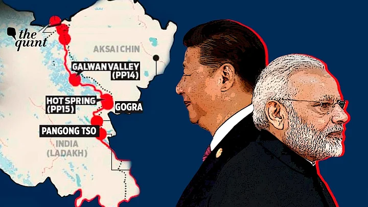
As per the BPTA, the Chinese agreed that they would clarify the 18-20 points in the LAC where there were differing perceptions. But as time went by, they refused to do so. And instead used these points like Depsang, Pangong Tso, and Demchok in the west and Yangtse, Asaphi La, and others in the east to keep the LAC live. Mind you Galwan, Gogra, and Hot Springs were not identified as problem points in the 1990s.
Incidentally, one of the big initiatives of the Modi government was to get China to somehow clarify just where the LAC lay. In his visit to China in 2015, Modi repeatedly called on the Chinese to work along the BPTA and clarify the LAC so that there would be no inadvertent clashes.
But the wily Chinese sidestepped. A few days later, an official told Indian journalists that the clarification would “create more problems”. Asked how this would happen, he refused to answer saying it was beyond his remit.
What is striking is that since 2020, the Chinese have once again begun to push the notion of the border as being defined by the 7 November 1959 line. In essence, what the Chinese seem to be saying is that what they claim to be the LAC, is the real LAC. And in the meantime, they have felt free to define it the way they want to.
(The writer is a Distinguished Fellow, Observer Research Foundation, New Delhi. This is an opinion piece and the views expressed above are the author’s own. The Quint neither endorses nor is responsible for the same.)