Unprecedented Flooding Ravages Yellowstone National Park, All Entrances Closed
All entrances to the park were closed for the first time in 34 years, apart from a short while during the pandemic.
advertisement
Unprecedented floodwaters have ravaged Yellowstone National Park and surrounding communities, washing roads and bridges away, cutting off electricity and prompting park evacuations during the peak of the summer tourist season since Monday, 13 June, CNN reported.
Some of the worst damage took place at the northern part of the park and at Yellowstone’s gateway communities in southern Montana, the report added.
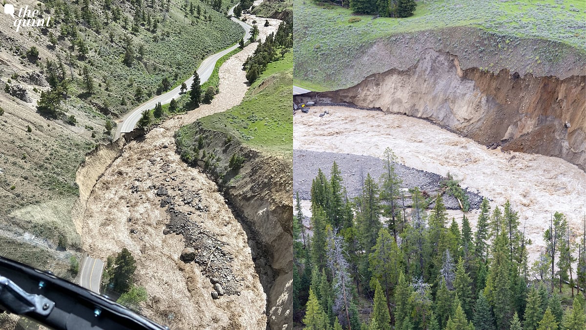
Pictures and videos from Yellowstone showed landslides, a bridge washed out over a creek, and roads badly undercut by churning floodwaters of the Gardner and Lamar rivers.
Predominantly located in Wyoming, the park spreads into parts of Montana and Idaho. The deluge severely affected the northern part of the park, along with gateway communities in southern Montana.
High Rainfall, Melting Snow
The floods occurred after the region saw extremely high rainfall after several years, which coincided with a spike in temperature, leading to melting snow at higher elevations.
Over the weekend, the storm in Yellowstone brought close to three inches of rain, which when combined with melting snow led to a fast-flowing flood.
Some of the worst damage happened in the northern part of the park and Yellowstone’s gateway communities in southern Montana. While there were no immediate injuries reported, dozens of stranded campers were rescued by raft.
According to CNN, the abundant rainfall and rapid snowmelt together can lead to three-fourth of a foot (9 inches) of water runoff, similar to almost three months of rainfall in three days.
With most roads, bridges and railroads currently inaccessible, officials have kept a few roads open to account for energy transport. Officials also warned residents of the possibility of displaced wildlife wandering into their properties, while some residents have already spotted bears, deers and domestic livestock, CNN reported.
Montana Governor Greg Gianforte, on Tuesday, declared a “statewide disaster” to “help impacted communities get back on their feet as soon as possible.”
(With inputs from CNN and The New York Times)