Video Producers: Aparna Singh, Shohini Bose
Video Editor: Prajjwal Kumar
Parts of Sikkim were hit with devastating flash floods on Wednesday, 4 October, claiming the lives of at least 21 people. Over 103 people are believed to be missing even as search and rescue operations by authorities are underway.
According to the Sikkim State Disaster Management Authority (SSDMA), the extreme flooding was witnessed in at least four districts, namely: Mangan, Gangtok, Pakyong, and Namchi. One of the state's largest hydroelectric project was also severely damaged due to the flash floods.
Long story short, the South Lhonak Lake is a glacial lake located at an altitude of 17,000 feet in Sikkim's northwest region. When the lake burst, water rushed downstream and led to a rise in the water levels of the Teesta River which, in turn, flooded the four districts.
But why did the glacial lake burst? Were there any warning signs? Can it happen again? If so, where? And what does all of this have to do with climate change? Here's the complete low-down.
What Do We Know About GLOFs?
A glacial lake outburst flood or GLOF is said to occur when glacial lake water suddenly and rapidly moves downslope as a result of dam failures, according to the Columbia Climate School.
The South Lhonak Lake is likely dammed by unstable ice or sediment composed of loose rock and debris (morraine-dammed).
The build-up of water pressure, ice and rock avalanches, earthquakes, erosion, and other natural disruptions can lead to a GLOF.
"These lakes are also often found in steep, mountainous regions, which means landslides or ice avalanches can sometimes fall directly into the lakes and displace the water, causing it to over-top the natural dam and flood downstream," University of Canterbury (New Zealand) lecturer Tom Robinson was quoted as saying by The Indian Express.
Are GLOFs Unpredictable?
Yes, GLOFs can be unpredictable when there is a lack of sufficient data on rainfall intensity, location of landslide, impounded volume, physical condition of lakes and water bodies. Additionally, climate change and human intervention reportedly increases the risk of GLOF disasters.
Is South Lhonak Lake Vulnerable to GLOFs?
South Lhonak Lake has reportedly been on the radar of the government authorities for years now. A report published by the Sikkim Forest and Environment Department shows that the area of the bullet-shaped lake has significantly increased in the past five decades.
“Lhonak has grown nearly 1.5 times and South Lhonak nearly 2.5 times of their initial size in 1989… An earthquake of magnitude 4.9 on Sept 21, 1991 (as reported by United States Geological Survey) near the parent glacier feeding the South Lhonak Lake and the recent earthquake (magnitude 6.9) of Sept 18, 2011 approximately 70 km from the lakes and future earthquakes may trigger the GLOF events."Sikkim Forest and Environment Department Report
Not just the Sikkim government, several independent researchers also raised alarm bells about the South Lhonak Lake being susceptible to GLOF as a result of its melting glacier.
For instance, one of the key findings of a 2021 study titled 'Future Glacial Lake Outburst Flood (GLOF) hazard of the South Lhonak Lake, Sikkim Himalaya' was that "many settlements and assets located along the river channel at Chungthang are potentially exposed to future GLOFs."
"The width of the terminal moraine that dams the South Lhonak Lake is not uniform and is thinning towards the ends. Hummocky surface of the dam indicates that it likely contains buried ice and be subject to future degradation," a 2021 study had cautioned.
The study had further recommended that a full environmental impact assessment be undertaken as well as GLOF risk mitigation measures.
What Was the Tipping Point for the South Lhonak Lake?
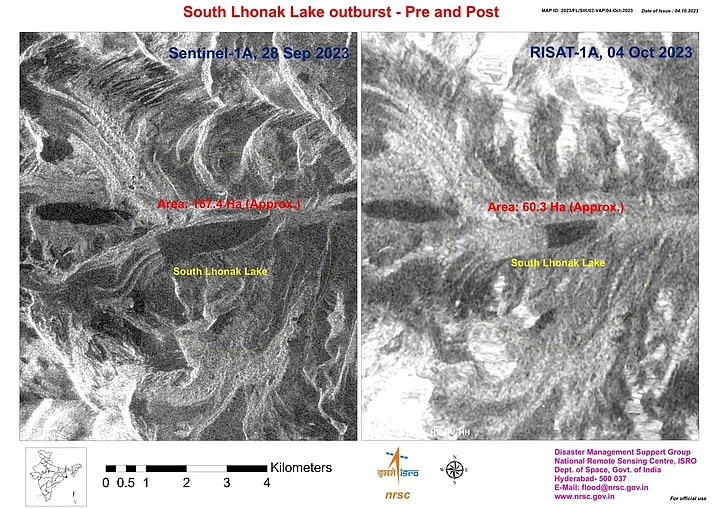
- 01/02
Pre & Post view of South Lhonak Lake as observed by RISAT 1A as on 4 October 2023 at 0600 hrs and Sentinel 1A as on 28 September 2023 at 1800 hrs.
(Photo Courtesy: ISRO)

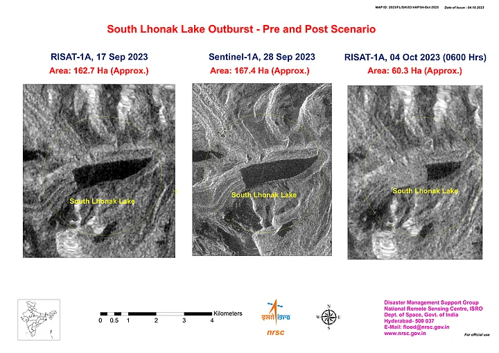
- 02/02
Temporal changes in the lake area as on 17 September 2023, 28 September 2023, and 4 October 2023.
(Photo Courtesy: ISRO)
The primary reason for the GLOF event at the South Lhonak Lake is likely "excess rainfall", according to the National Disaster Management Authority (NDMA) which added that scientists are still investigating the exact cause.
As per the weather department, the area where South Lhonak Lake is located has recorded nearly 50 mm rainfall (48 percent increase) since Sunday, 1 October.
"We're facing a devastating flash flood in the Teesta River, Sikkim. Information is fragmented, but it appears heavy rainfall from a Bay of Bengal low-pressure depression triggered the disaster. This seems like another unfortunate example of cascading hazards," International Centre for Integrated Mountain Development (ICIMOD) senior climate change specialist Arun B Shrestha was quoted as saying by Hindustan Times.
However, another theory that's emerged is that the recent earthquake in Nepal forced the GLOF. India Today reported that experts who visited the site believe that the earthquake may have triggered the disaster as "cloud bursts do not cause such results."
On Tuesday, 3 October, Nepal witnessed a 6.2 magnitude earthquake with strong tremors reported in Delhi-NCR and other Indian cities such as Uttar Pradesh's Lucknow, Amroha, and Hapur. Several videos went viral on social media showing the effects of the tremors.
How Can the Government Take Action?
In 2016, 150 litres of water per sec was mindfully siphoned off from the South Lhonak Lake. The work was jointly undertaken by members of the Sikkim State Disaster Management Authority and Sikkim’s Department of Science and Technology and Climate Change.
Innovator Sonam Wangchuk (of 3 Idiots fame) came up with a technique to siphon off the water and it was implemented under his supervision using three eight-inch wide and 130-140 metres long High Density Polyethylene (HDPE) pipes, The Indian Express reported.
It is unclear if similar work was carried out more recently at the site of the lake.
"We are all aware of the recent natural calamity that has struck our state. Emergency services have been mobilized to the affected areas, and I personally visited Singtam to assess the damages and engage with the local community," Sikkim Chief Minister Prem Singh Tamang wrote on X.
Prime Minister Narendra Modi also dialed the CM and reportedly assured him of support from the Centre.
Meanwhile, the Indian Army has launched three helplines for the families of those missing amid the deadly floods, including the army's own soldiers.
Army Helpline No for North Sikkim – 8750887741
Army Helpline for East Sikkim – 8756991895
Army Helpline for missing soldiers – 7588302011
Are GLOFs Preventable or the New Normal?
The glaciers in the Sikkim Himalayan region have been melting rapidly due to rising global temperatures. As a result, many glacier lakes in the mountainous region are quickly becoming larger in area.
Currently, 10 out of 300 glacial lakes in the Sikkim Himalayan region are vulnerable to outburst, according to a report by Mongabay.
A similar climate event had taken place in 2013, when the Chorabari Tal glacial lake had burst in Uttarakhand's Kedarnath which had claimed the lives of thousands of people.
"The most important mitigation measure for reducing GLOF risk is to reduce the volume of water in the lake in order to reduce the peak surge discharge," read a report by the International Centre for Integrated Mountain Development (ICIMOD).
In order to reduce the volume of lake water, the ICIMOD report recommended:
Controlled breaching
Construction of an outlet control structure
Pumping or siphoning out the water from the lake
Making a tunnel through the moraine barrier or under an ice dam