Many scientists believe that a colossal earthquake is due very soon in the Himalayas. They expect at least one of 8.1 to 8.3 M—though seven such quakes are overdue. A giant earthquake of this magnitude could snuff out 10 million lives in the Indo-Gangetic Plain.
Given the possibility of giant earthquakes striking India, the country must have teams of experts to advise policymakers and the public on geology, mitigation engineering, and disaster management in order to reduce loss of life and property.
With this background, I had conceived the Gondwanaland Expedition. Driving from the Indian Himalayas where India met Asia to Cape Agulhus, the southernmost tip of Africa, across 17 countries of West Asia and Africa, the expedition would traverse through several areas of importance in the evolution of the earth.
It would give the expedition scientists an opportunity to conduct exploratory research, review and synthesise existing knowledge while getting acquainted with and observing the geological and natural features. The expedition would drive across the East-West treading belts of suture zones, sites of the closed Tethys Sea at several places in quake-prone Northern and Southern Iran and Turkey.
Navigating geology of Quake-prone terrains
Along the way, the scientists would exchange knowledge on past earthquakes and ongoing seismicity with scientists of 30 universities and research institutions, thereby, furthering their understanding of the earthquake geology. As the expedition would be driving along the Great Rift Valley from Syria to Mozambique, the geochemical evolution of the volcanic rocks of the rift system could be taken up for study in order to gain a better understanding of its evolutionary history.
Traversing Iran from South to the North, the expedition Scorpios zipped on the highway through the Zagros Mountains, folded and faulted beyond repair. We drove along a sequence of green, brown, and grey rocks oozing glaciers of white salt. This region is actively undergoing crustal shortening as global tectonics moves Arabia toward Asia.
Consequently, the layers of sedimentary rock are folding much like a carpet will fold if pushed. The salt deposits, created by the evaporation of an ancient inland sea, were buried by these layers of sedimentary rocks. Salt, being less dense than most other rocks, migrates upwards through the earth's crust in vertical columns before being released like a glacier.
Iran's Seismic Gullibility
Iran comprises five microcontinents, fragments of land that joined together during different time periods. The Iranian Plate is still pushing into the Asian Plate, raising the height of the Zagros Mountains. That makes Iran seismically hyperactive and terribly prone to earthquakes.
In 2003, an earthquake in Bam, in South-eastern Iran, killed 15,000 people and flattened 70% of the houses. In 1993, another killer quake took 35,000 lives in the same city. On an average, Iran gets rocked 50 times a week with earthquakes of up to 5.0 M, and once a year by a quake higher than 6 M. While we were in Shiraz on March 31, 2006, an earthquake of 5.8 M hit Khorramabad in Lorestan Province, killing 70 people, injuring 1264 and destroying eight villages. It was followed by forty aftershocks over the next two days.
From Tehran we headed for earthquake-prone Tabriz, 599 km away, in Iranian Azerbaijan, driving through a tectonic valley. As we moved towards the Turkish border, we entered Maku, hemmed tight between two striking granite mountain ranges covered with a tangle of massive boulders delicately balanced, awaiting the next earthquake, ready to tumble down and crush the township.
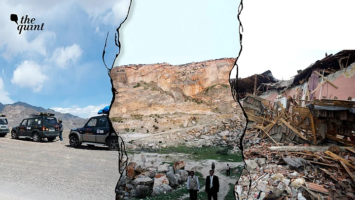
In Turkey, we drove through Eastern and South-eastern Anatolia, just North of the Iraq border, a restive region of Turkey, affected by the violent separatist movement for an independent Kurdistan. This is the region, one of the most beautiful on our planet, that has been flattened by the recent earthquake.
Tracing Turkey's faultlines
Leaving Dogubeyazit, settled since the Urartu period over 2,700 years ago, our stout-hearted Scorpios climbed higher and higher along the towering walls of ice, on roads wet with melting snow.
From the top of a high pass at 6,501ft past the village of Somkaya, we looked down into a wonderland of snow, a grand sweep of a stark white valley, its floor layered with black rocks, scree and crags. Spires and pitted cliffs rose from the white carpet of deep snow.
Eons ago volcanoes erupted porous rock, filling this basin. Water and wind wore away much of the rock, leaving a moonscape – pinnacles, cones, towering toadstools and melting pyramids. There was a deep hush all around with not the faintest breath of wind, nor stir of grass. The haunting sense of isolation, loneliness and remoteness was entirely satisfying.
We descended slowly into the fractured bowl, driving on a raised road above a flooded river of white snow and solidified black lava. It was a breathtaking scenery. When the geologists told us that we were driving on an active “strike-slip fault line”, it took away whatever breath was left in us.
We stepped on the accelerator. Turkey’s most worrying crack is the North Anatolian Fault that runs beneath the Sea of Marmara to Istanbul, threatening to rupture sooner than later. It did so on 6 February, 2023 – 17 years after our visit. Earlier, the 7.6M earthquake of 1999 had devastated Izmit and Adapazari, killing over 18,000 people.
Turning left on A975 to Van, the rollercoaster highway cut through a range of mountains. Driving past the township of Muradiye, Lake Van suddenly revealed itself. The 3,750 sq km lake is the largest body of water in Turkey and the second largest in the Middle East. Its enchanting setting, its blue-white waters rimmed with a series of snow-clad volcanoes, their summits touching the billowy clouds, makes the lake exceedingly pleasant to the eyes – though few venture to come here.
Once Verdant Scenery Now Turned to Hellscape
Crossing the eastern extension of the Taurus Mountains, still covered in deep snow, we got to Tatvan, a small Kurdish township on the Western edge of Lake Van. Our course continued through the Taurus range. The descent from the mountains was long and arduous. Landslides had wrecked the road. The sharp curves and the continuous oncoming traffic of heavy trucks added to our woes. The frequent sight of trucks rolled down the mountain slopes didn’t make things any easier.
Getting off the Taurus Mountains, we drove into a sea of greenery. The road dipped and rose through undulated and wonderfully fertile landscape. Green wheat fields were intercropped with mustard, its yellow flowers swaying in the gentle breeze and soft, golden sunlight falling from a deep blue sky.
Crossing the Tigris River, we entered Diyarbakir, a teeming city enclosed within ancient walls made of forbidding black basalt during the Byzantine period. As embattled now as when the Romans fought the Persians here, Diyarbakir has been the hotbed of Kurdish nationalism. Today, it is a rubble.
The eucalyptus-lined road to Syria continued through undulating land with wheat fields intercropped with yellow mustard; through pistachio plantations on large tracts of rust-colored soil, and through huge plantations of olives, still in a state of vegetative growth.
We glided past the ancient town of Sanliurfa that fostered trade around 2600 BC and from where Abraham began his trek to Canaan. Nearby was Harran where Adam and Eve, expelled from Eden, learned to farm. At Birepik, we crossed the Euphrates River.
Though Euphrates had more water than the Tigris, the South-eastern Anatolia Project, one of the largest public works efforts in the world, has tapped the waters of both rivers, irrigating 9.5% of the land area in Turkey. The project’s 22 dams generate electricity from 19 hydroelectric plants. From Gaziantep, the epicentre of this week’s earthquake, we turned south towards Kilis, close to the Syrian border.
At Aleppo, devastated by the present quake, the Syrian geologists told us that it was here in Lebanon and Syria that the Great Rift Valley began, born with the intermittent swelling and cracking, faulting and settling – a process that began hundreds of millions of years ago and still continues today.
As earth’s crust cracked under internal stresses, great blocks between parallel faults collapsed, leaving mile-high ridges and deep-cleft valleys. The valleys flooded to form the Sea of Galilee, the Dead Sea and the Red Sea. Aleppo is located on two tectonic plates, the collision between Arabian and Eurasian plates, and on the Red Sea Rift, making it vulnerable to earthquakes.
Even here rose the spectre of Arab-Israeli conflict. Dr Anis Matar, otherwise a mild, affectionate gentleman, told us in a raised voice, clenching his fist, that the Israelis were detonating explosives under the bed of the Dead Sea with the purpose of causing earthquakes in Syria and the Arab lands. “This is geological terrorism,” thundered the professor with considerable exaggeration.
(Fellow of the Royal Geographical Society, Fellow of Explorers Club USA, Editor of Indian Mountaineer, Akhil Bakshi is an author and explorer)