The Quint is telling the full story of how climate change is reshaping lives in India. Help us do more. Become a member.
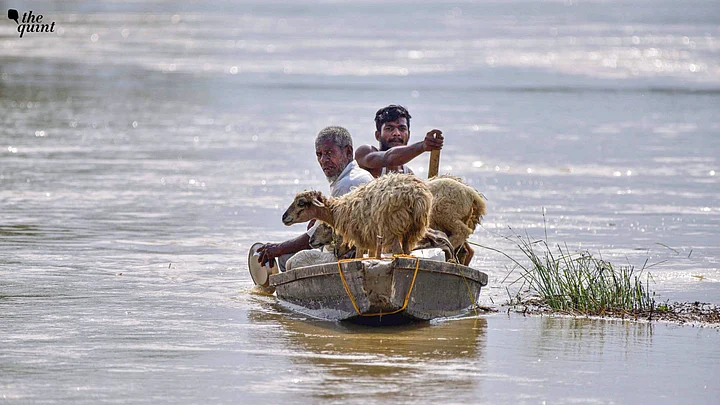
Heavy rainfall has caused severe flooding in Assam’s Dhemaji district, damaging a railway bridge and disrupting train services. According to the State Disaster Management Authority, nearly 16,000 people have been affected by the floods across 69 villages.
Authorities have advised residents to avoid unnecessary travel and remain vigilant, as the India Meteorological Department (IMD) forecasts continued heavy rainfall in Assam and neighbouring states.
The ongoing weather conditions have prompted officials to remain on high alert for further flooding, landslides, and disruptions to transport and essential services as details emerged.
While unfortunate, this is nothing new for the region. As one of the most flood-prone regions in the world, the Brahmaputra basin experiences recurring monsoon floods each year, often marked by submerged agricultural land, rescue efforts, temporary relief camps, and emergency ration distribution. In 2022, Assam experienced a series of floods from April to October, marking one of the most severe flood periods in recent years.
Once the water recedes, however, communities trying to return and rebuild often find their land permanently reshaped or eroded.
Beyond Flood Relief: Planning for Climate-Induced Migration
Data from Assam's Water Resources department highlights that riverbank erosion has become a major issue for the last six decades.
Since 1950, the Brahmaputra and its tributaries have eroded over 4.27 lakh hectares of land, accounting for 7.4 percent of the state’s total area. Assam continues to lose nearly 8,000 hectares of land every year, forcing many farmers to become landless internal migrants.
To address flood-induced displacement and migration, we must move beyond the reactive cycle of emergency relief.
We need a proactive policy framework that recognises climate-induced flooding and migration as recurring and growing challenges.
Odisha and Telangana offer examples of planned responses to climate-induced displacement. Odisha supports adaptive agriculture and safe migration through a UN Joint Programme on Climate Change and Migration. Telangana, too, supports climate-vulnerable households through skills training, adaptive capacity, and safe migration initiatives under the same programme.
The River is Changing
The current standard mitigation plan for Brahmaputra’s changing morphology has relied on the construction and repair of embankments. However, overreliance on such hard structures can disrupt the river's natural course and unintentionally reduce the long-term regional adaptive capacity of local communities.
When embankments breach unexpectedly, the resulting damage is often more severe than that from gradual inundation.
Top-down engineering interventions frequently ignore traditional ecological knowledge.
Indigenous communities, such as the Mishing tribe of Majuli Island, have historically developed adaptive living strategies, including stilt housing (chang ghar) and flexible agricultural calendars, to coexist with the river.
In addition, the disaster response to flooding also falls into a repetitive cycle of rescue efforts, temporary relief camps, providing rations, and, at times offering minimal financial ex-gratia for immediate flood-related displacements and land loss.
While such measures are necessary, they do not address the lack of legal compensation for gradual erosion that occurs throughout the year, resulting in permanent loss of land and livelihoods.
Embedding Climate Mobility in Assam's Policy Framework
To break this vicious cycle, policymakers must adopt the concept of Climate Mobility, a principle first recognised in UN’s Cancún Adaptation Framework of 2010, which categorises climate-induced human movement into displacement, migration, and planned relocation.
Several other frameworks, like the Paris Agreement, Sendai Framework, and the Nansen Initiative, have since pushed for embedding climate mobility within national and state-level climate and disaster-management plans.
The Global Compact for Migration, adopted by the United Nations in 2018, also recognises climate change as a driver of migration and outlines strategies to prepare for displacement and build resilience.
India has integrated many of these global frameworks into national and state policies by linking climate adaptation, disaster management, resilient infrastructure, and rural development.
However, gaps remain in implementation, especially in addressing climate mobility and community resilience.
Riverbank erosion continues to be excluded from the list of natural calamities covered under the National Disaster Response Fund (NDRF) and State Disaster Relief Fund (SDRF) guidelines, which mainly support sudden disasters such as floods, cyclones, and earthquakes.
This is because riverbank erosion is viewed as a predictable, structural, geomorphological evolution requiring long-term engineering and resettlement planning rather than emergency relief.
As a result, Assam has relied largely on limited state resources and external funding to address permanent land loss, leading to delays in compensation and resettlement for displaced riverine communities.
Displaced populations, particularly from shifting riverine islands (chars), face legal and spatial marginalisation as riverbank erosion fractures community ties, compromises access to basic services, and disproportionately affects women and children.
Without institutional support, people who move to urban areas to find a livelihood often face debt bondage, underemployment, and labour exploitation.
Supporting people to migrate safely before environmental conditions worsen can reduce both human and economic costs.
Transitioning from a reactive disaster response to a proactive climate mobility framework requires a coordinated institutional shift across departments such as the the state disaster management body, Water Resources and Agriculture departments, and others.
Policy must be guided by predictive science rather than post-disaster assessments, utilising advanced satellite geomorphology and hydro-dynamic modeling to map "vulnerability surfaces" along the Brahmaputra.
Identifying high-risk erosion zones before a riverbank collapses allows the state to project displacement numbers and establish structured rehabilitation zones along with preemptive access to healthcare and education.
Finally, because land loss strips communities of agrarian assets, spatial rehabilitation must be paired with an economic transition to ensure long-term financial independence and community resilience.
While several strategic dam projects on the Brahmaputra are in the pipeline, planning and rollout of a climate mobility framework will yield immediate results.
By moving beyond reactive disaster relief, the state can secure a safer, more just, and resilient future for its riverine population.
[The author is a communications professional based in New Delhi with experience at the Ministry of Environment, Forest and Climate Change (MoEF&CC) and the United Nations International Organisation for Migration. Born in Assam, she closely follows developments across the state and the North East region. This is an opinion piece and the views expressed are the author's own. The Quint does not endorse or is responsible for them.]