
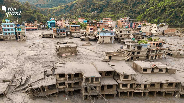
The first lesson from the catastrophe in Nepal’s Rasuwa district is also the most uncomfortable: the Himalaya does not recognise political borders.
On the morning of 26 August, a large mass of ice and rock appears to have broken away high in the Himalaya near the Nepal-Tibet-China border.
Satellite imagery indicates a substantial collapse associated with the Langtang Lirung area, while geological analysis points to the failure of both glacier material and underlying bedrock. The resulting mass entered the Lhende Khola system and generated a violent mixture of water, ice, mud, rock and sediment that travelled downstream through the Bhote Koshi and ultimately the Trishuli river system wiping out villages, homes, roads, and bridges.
Nepal death toll has risen to 469, while more than 1,000 remained missing. The numbers are changing rapidly as more dead bodies are being recovered from the debris. The MEA also said on 27 August that 288 Indian nationals were still unreachable, including 73 working on the Trishuli-1 power project and several groups of Kailash Mansarovar pilgrims.
The chain of events is still being investigated. The emerging evidence, however, points towards an ice-rock avalanche or glacier collapse rather than allowing us to confidently label the event a conventional Glacial Lake Outburst Flood (GLOF).
For those of us who come from the Himalayas, mountains are never just mountains. They are roads we travel, rivers we cross, forests we depend on and slopes we learn to read almost instinctively. I come from Jammu and Kashmir, in the western Himalaya and have spent years writing about what happens when extreme weather collides with fragile terrain and expanding infrastructure. So, watching the devastation in Nepal does not feel like witnessing a distant disaster. The images carry a particular familiarity of the Chasoti Cloud Burst in Kishtwar. They have already shown how quickly a mountain landscape can turn dangerous.
That is precisely why Nepal’s disaster deserves to be examined not simply as another Himalayan flood, but as a warning about how little we understand and how poorly we monitor and develop a rapidly changing mountain system.
63,700 Glaciers, but No Common Monitoring System
The Himalayas contains more than 63,700 glaciers. Yet monitoring remains sparse and uneven across the region.
The International Centre for Integrated Mountain Development (ICIMOD) Regional Cryosphere Strategy, released in August 2026. makes the problem explicit despite the enormous number of glaciers, only 18 percent of the 38 glaciers currently monitored meet the World Glacier Monitoring Services benchmark standards. Major glacierised areas remain poorly monitored, meaning that even where data exist, they do not necessarily provide a collective picture of how the regional cryosphere is changing.
GLOFs have rightly become a major concern across the Hindu Kush Himalaya. But the danger is larger than glacial lakes themselves.
ICIMOD’s latest assessment says the rate of glacier ice loss across the Hindu Kush Himalaya has doubled since 2000, while the region’s glaciers have lost as much as 27 metres of ice thickness since 1975. This is why calling the Himalaya merely a “fragile ecosystem” is no longer sufficient. It is a dynamic geological and climatic system undergoing rapid change. And our monitoring systems must reflect that reality.
The Indian Himalaya Is Facing the Same Risks
Nepal is not an isolated Himalayan exception. The same combination of warming, glacier retreat, unstable slopes, changing precipitation, permafrost degradation, extreme rainfall and expanding infrastructure exists across the Indian Himalaya.
Just over a year ago, the Himalaya gave Jammu and Kashmir its own brutal warning. On 14 August, 2025, a cloudburst struck Chasoti in Kishtwar district, near the route to the Machail Mata shrine. Flash floods tore through the settlement, killing at least 65 people and injuring more than 100.
The disaster was different from Nepal’s event. There is no reason to artificially connect the two through the same immediate trigger. But the underlying lesson is strikingly similar.
In both cases, people were concentrated in narrow Himalayan valleys where extreme water and debris can move with terrifying speed. Connectivity was vulnerable. Settlements and infrastructure occupied exposed terrain. And once the event began, the geography itself made rescue difficult.
Other catastrophic examples include, Chamoli, Uttarakhand, 2021, rock-and-ice avalanche followed by a devastating debris flow. South Lhonak, Sikkim, 2023, A GLOF destroyed infrastructure and severely damaged the Teesta basin.
India was already monitoring hundreds of glacial lakes through satellite observations. Government data submitted to Parliament showed that from 2022, 902 glacial lakes and water bodies were being monitored using remote sensing, including 544 glacial lakes larger than 10 hectares. Yet South Lhonak did not have an operational early-warning system when it burst. A water-level sensor installed in 2016 had failed after six months because of extreme conditions at high altitude.
That should force a difficult question. If a lake is identified as potentially dangerous but the monitoring instrument cannot reliably survive where the danger exists, what exactly are we monitoring?
One Himalayan System, Divided by Political Borders
The Himalayas function as one interconnected geological and hydrological system, but our understanding of it remains divided along national boundaries.
Glaciers, rivers, slopes, snow, and permafrost do not stop at borders. A collapse or sudden release of water high in one country can become a disaster downstream in another. That raises a fundamental question: If the physical system is interconnected, why are we still monitoring it largely as separate national territories? The answer cannot simply be more data within individual countries. What the region needs is compatible, continuously updated and shareable information.
The communities living closest to the Himalayan hazards are often among those who have contributed the least to the greenhouse-gas emissions driving global warming.
Yet they are increasingly confronting climate disasters. For millions of mountain residents, climate change is not an abstract projection for 2050. It is already altering the landscape around them. The Hindu Kush Himalaya is home to more than 270 million people, while its river basins serve more than two billion people downstream. That makes the fate of Himalayan communities a global climate issue, not merely a regional one.
When Development Outruns Himalayan Risk
There is another uncomfortable question. How much infrastructure are we placing inside a landscape whose physical behaviour is changing faster than our risk maps?
Nepal’s latest disaster damaged at least 13 hydropower projects, including eight operational projects with a combined capacity of 354 MW and five under construction. This does not mean hydropower itself caused the disaster. It means something more basic: infrastructure has become deeply embedded in the pathways through which Himalayan hazards move.
The same concern applies across India. Development is necessary, mountain communities need roads, electricity, communications and livelihoods.
But development cannot begin with the assumption that a mountain is simply empty land waiting to be engineered. A glacier is not a reservoir waiting to be measured. A river is not merely a channel waiting to carry a project. A slope is not stable simply because it has remained standing for decades. And the Himalaya is certainly not a blank slate.
The Data Problem Nobody Wants to Discuss
Perhaps the most important question raised by the Nepal disaster concerns information. The data problem is not hypothetical. India has already experienced what happens when information across Himalayan borders becomes uncertain. An RTI response from the Ministry of Jal Shakti revealed in 2025 that China had shared no hydrological data or information on hydro structures with India since 2022. The bilateral arrangement for Brahmaputra data, intended to help India with flood forecasting, expired in June 2023 and has not been renewed.
If a potentially catastrophic event originates on one side of a political boundary and its consequences arrive downstream on another, who sees the warning first? Who owns the satellite data? Who monitors the glacier?Who monitors the unstable slope? Who measures river levels? Who decides when an alert becomes an evacuation order? And, most importantly, how quickly is that information shared across borders?
The Himalayas stretches across eight countries, while its rivers connect populations and infrastructure far beyond national boundaries. A hazard developing in one country can become a disaster in another within minutes or hours. Regional scientific cooperation therefore cannot remain limited to conferences, reports and post-disaster assessments.
We need systems capable of sharing near-real-time information on high-risk glacial lakes, glacier movement, unstable slopes, extreme rainfall, river levels and emerging blockages.
But geopolitics is only one part of the problem. In 2023, when the South Lhonak glacial lake burst in Sikkim, India already knew the lake posed a risk. Yet a water-level sensor installed there had failed after roughly six months in the extreme high-altitude environment. The disaster exposed a different vulnerability: we can identify hazards and still fail to receive the information needed to act on them.
In such a landscape, when the event begins across a national boundary, monitoring cannot remain confined to individual hazards or national jurisdictions.
Thus, Nepal’s tragedy must not become another disaster story that fades when the rescue ends. We need shared data, stronger monitoring, reliable early warnings, and development that respects the limits of the terrain.
(Kanwal Singh is a writer and political analyst. This is an opinion piece and the views expressed are the author's. The Quint does not endorse or is responsible for them.)
