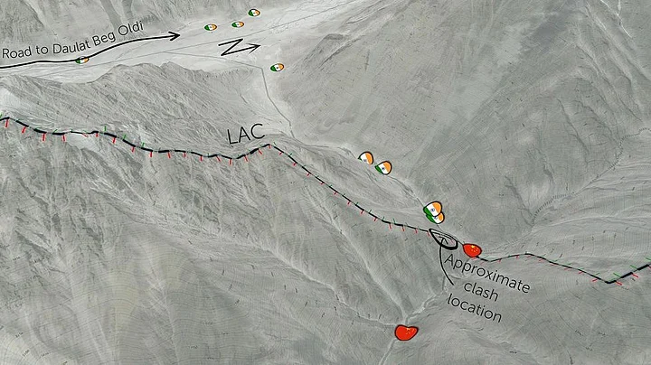
Twenty Indian soldiers were killed in action while dismantling illegal Chinese camps at Galwan Valley on 15 June. While the country is mourning their loss, the exact details of what happened on the night in this disputed region and what is the current situation remain vague.
The analysis of satellite imagery from late May and early June by Nathan Ruser of the Australian Strategic Policy Institute gives a glimpse into the force buildup at the border, and the location, where the violent attacks took place. However, this report has been disputed by several Indian defence analysts.
The satellite imagery and its analysis also give detailed information on the three disputed areas – the Galwan River Valley, Hot Springs and Pangong Tso.
Galwan Valley
The report focuses first on the Galwan Valley, which is centre of the standoff, where the 20 Indian soldiers were killed in the action. Satellite images shows that the People’s Liberation Army (PLA) has deployed up to 1,000 soldiers and has established significant positions in the valley.
“Until May, the PLA didn’t have positions within the valley, despite several kilometres being on the China-controlled side of the LAC. However, recently established Indian positions closer to the LAC, and the construction of a road to supply these positions, appears to have prompted the PLA to establish a number of significant positions and move up to 1,000 soldiers into the valley.”
The analysis of imagery near Patrol Point 14, which is a sandbank along the LAC, shows “a small number of tents and likely fewer than 50 Chinese soldiers”. The reason for the PLA to occupy ridgeline position is to observe the traffic on the recently completed Darbuk–Shyok–Daulat Beg Oldie road and Indian military bases.
Clearly, this explains why Indian troops were sent in to remove this position, which was agreed upon during the commander level meetings, especially the one on 6 June. Indian troops dismantling this position led to the violent attack from PLA that resulted in 20 Indian causalities.
According to the report, satellite imagery on 16 June, the morning after the deadly attack along the LAC, shows both the Indian and Chinese forward most positions that had been dismantled over the past week.
It also shows that India had set up a temporary position within 50 metres of the LAC, which the analyst believes could be a casualty collection point. On the Chinese side, a group of around 100 trucks can be seen. “It’s not clear if these trucks are reinforcing the area with troops or dismantling positions in accordance with the disengagement agreement between India and China,” read the report.
Hot Springs Area
South of the Galwan River Valley lies the Hot Springs area. Here, satellite imagery from late May shows dirt track up to 1 kilometre into Indian-controlled territory. It also shows a looped dirt track that crosses nearly 500 metres into Indian-controlled territory.
“The fact that it’s a circular track suggests that it may be a regular patrol route. There are no PLA positions on the Indian side of the LAC; however, these tracks suggest that PLA forces are regularly making incursions into Indian territory, at a remote part of the LAC that is 10 kilometres from the nearest Indian positions,” read the report.
India, on the other hand, is constructing a permanent position along the river valley in a position that overlooks the LAC.
Pangong Tso
In Pangong Tso, as per the Indian perception of the LAC, the border is at Finger 8 (marked in the map). However, satellite images show that the PLA has come in way inside the LAC up to finger 4, where PLA structures could be found.
The report says that the PLA constructed between 500 structures, fortified trenches and a new boat-shed between fingers 4 and 5, which is way ahead of their original position. There seems to be more structures under construction.
“The scale and provocative nature of these new Chinese outposts is hard to overstate: 53 different forward positions have been built, including 19 that sit exactly on the ridge-line separating Indian and Chinese patrols,” read the report.
Analyst’s Take on the Report
Defence Analyst Brahma Chellaney played down the analysis by the think tanks. “This analysis, while claiming to be of satellite imagery, is largely based on deceptively created maps, other than at Lake Pangong. It depicts a fictional Line of Actual Control, thus hiding China's encroachments in Galwan Valley and Hot Springs,” he tweeted.
In an argument that ensued on Twitter, the author of the report countered Brahma. “This Line of Actual Control actually comes from Indian sources (namely detailed geographic data from India's Department of Environment),” he tweeted.
In response, defence analyst Brahma, tweeted: “No combination of pretty colours or flags on contrived maps can change basic facts. These maps reflect China's freshly minted claims to Galwan Valley and Hot Springs/Gogra. India has no "Department of Environment." Environment folks don't keep data on LAC.”
Despite the criticism, the Australian Strategic Policy Institute stands by its report.
(The details and maps from the report have been republished with permission.)
