One wouldn’t be far off the mark if one said, Indian history is thoroughly mottled with the remains of several empires – from before Jesus Christ was born, right until the period of the Delhi Sultanate. Battles have been fought and territorial boundaries have been drawn and redrawn, time and time again.
Thomas Lessman, a US-based historian, who has been researching world history for nearly 20 years, has designed a series of maps depicting Indian territory from 150 BC to the Delhi Sultanate in early 16th century.
Lessman has uploaded these maps on his website for all to see.
These maps start from the time when the Maurya Empire collapsed to the fall of the Delhi Sultanate.
We can guarantee that there aren’t very many maps like Lessman’s when it comes to the rich and illustrative chronicling of history. Take a look for yourself.
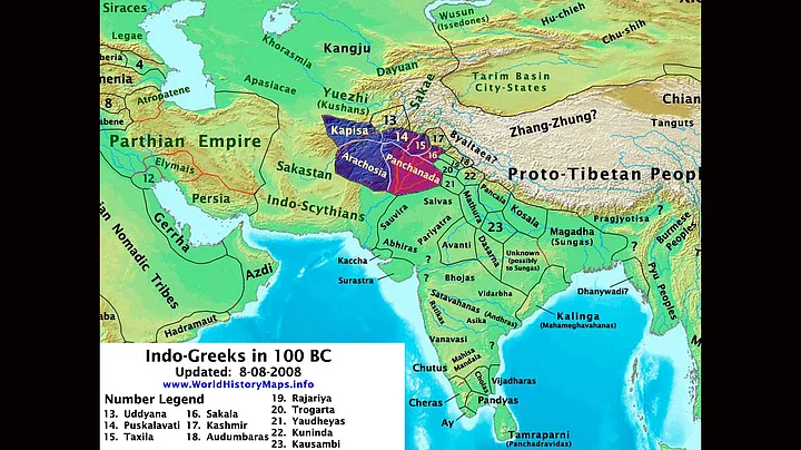
Period –100 BC to 10 BC: After the Maurya Empire had collapsed with the assassination of Emperor Brihadrata around 180 BC, the Indo-Greek kingdom, the Indo-Parthian Empire and Indo-Scythian kingdom were established.
Period – 001 AD: The Indo-Greek empire ruled India from 1 AD until 3 AD, during which time the fusion of Indian and Hellenistic influences flourished. The Indo-Scythian kingdom – also known as the Sakas – had also made their presence felt at the time. The Sakas were descendants of people who migrated from Russia and were the ones who later displaced the Indo-Greeks.
Period – 68 AD to 100 AD: Around 68 AD the Kushan Empire was established by the Kujula Kadphises. However, it was around 100 AD that the kingdom reached its peak under Kujula’s grandson Kanishka. Around 78 AD, Gautamiputra Satkarni took over Satavahana Empire and defeated Scythian king Vikramaditya.
Period - 400 AD: Around this time period the Gupta Empire flourished and unified the whole of the subcontinent. Art, literature, astronomy and even science saw a lot of progress. Meanwhile, the Huna empire also expanded to parts of Iran and parts of north-west India (now Afghanistan) which is why during the Mahabharata, the involvement of certain Huna tribes have been found.
Period – 700 AD: Between the 6th and the 12th century, the Chalukyas ruled in the south of India, while the Chachas ruled north-west India (present Pakistan and even parts of Afghanistan. At the time, the region was better known as Sind.
Period – 1000 AD: During this time, north-west and west India was ruled by multiple kingdoms including Chauhanas, Sumras and Solankis. The Gurjar-Pratihara dynasty ruled what is presently known as Uttar Pradesh, and the Chola empire established themselves in present-day Tamil Nadu. Meanwhile, the Ghaznavid Empire was ruling Iran and neighbouring regions.
Period: 1200 - 1500 AD: The Delhi Sultanate was established. It was the first ever Muslim kingdom which expanded between 1200 AD to 1526 AD. The rulers were descendants of the the Ghaznavid Empire.
The Delhi Sultanate was overthrown in 1526 – after which began the rule of the Mughal era.
During the downfall of the Delhi Sultanate, other than the Mughals, a new clan, the Rajputs, had also emerged and by 1500 AD, they too made their presence felt in western and north-western parts of India.
Meanwhile, in south India, the Vijayanagar Empire had build its stronghold.
(Historical inputs from Cultural India and History Discussion.)