Encroachment of lakes, tanks and drains, poor planning of drainage systems and lack of regulation of floodplains have exposed Bengaluru to the threat of urban flooding, say experts.
Multiple studies and reports have highlighted the vulnerability of the city to urban flooding. A 2017 study said that Bengaluru has lost 88 percent of its vegetation and 79 percent of its water bodies in 45 years.
Government data claims that the city earlier had a total of 260 lakes in 1940s which came down to 65 till now.
India’s Information Technology (IT) hub, Bengaluru, was recently in the limelight as it struggled to cope up with the recent urban floods triggered by the incessant rains in the last week of August and first week of September this year.
With a 131.6 millimeter rain in September this year, breaking records of the last 34 years, several IT parks in areas like Eco Space and other residential areas along Outer Ring Road, Bellandur, Marathahalli, Sarjapur and Mahadevapura were inundated with stormwater for days.
But what led to this large-scale stagnation of flood waters in parts of India’s fifth most populous urban agglomeration? Experts working on urban issues, lakes and flood management said that unabated urbanisation, large scale loss of green cover, encroachment of lakes, tanks and drains and lack of attention towards conserving and regulating floodplains of water bodies have increased the threat of urban flooding.
According to the disaster risk map of the city, Bengaluru has a total of 134 flood prone points in different parts of the city.
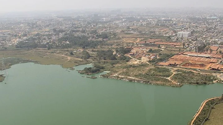
Now referred to as the Silicon Valley of India, because of its booming IT and startup businesses, Bengaluru was once also known as the “City of Lakes”. This moniker referred to the lakes and tanks which were made during the regime of earlier rulers and the British to cater to agricultural and other needs of the local population of Bengaluru.
However, increased urbanisation has seemed to have changed the local landscape of the city which is even evident publicly through satellite images of the city.
The Master Plan of 2015, prepared by the Bangalore Development Authority (BDA) claimed that the city once had 400 lakes but with the passage of time government data claimed that it was reduced to 260 by the 1940s and now has come down to 65.
The city of lakes owing to the undulating terrain of the city had a plethora of lakes that were inter-connected with a system of canals/drains called as (kaluve) which ensured transfer of excess water from one lake to another.
Although the city lacks a perennial river, the tributaries of Kaveri river such as Arkavathi, Pinakini/Pennar and Shimsha take the excess water from the city lakes and drainage system to the Kaveri river.
However, several experts and studies have pointed out the encroachments of the lakes and drainage system leading to interference in the city drainage system.
T.V. Ramachandra, Coordinator, Energy and Wetland Research Group
and Convenor at the Environmental Information system, Indian Institiute of Science (IISc) is one of the researchers in Bengaluru who has worked extensively on the issue of floods in the city.
His research paper titled Frequent Floods in Bangalore: Causes and Remedial Measure, published in August 2017, co-authored by Bharath Aithal (IIT-Kharagpur) and Vinay Shivamurthy (SR University, Warangal) sheds light on the issue of degradation of the city and its water bodies and its impact.
His study claimed that between 1973 to 2017, the urban areas of Greater Bangalore grew by 1028 percent.
The report claimed 88 percent decline in total vegetation cover and 79 percent decline in water bodies (wetlands) during the same period on account of increased concretisation of urban areas owing to cascading urbanisation.
Greater Bangalore refers to the areas of the Bruhat Bengaluru Mahanagara Palike (Bengaluru’s municipal corporation) and nearby areas including eight urban local bodies and 111 villages under urban Bengaluru. It was notified in 2006.
He told Mongabay-India, “One is we need to accept that global warming is real and changes in climate are happening. We are witnessing high intensity rainfall and we also are receiving a large quantity of water in shorter duration of time. Second is the unplanned and irresponsible urban planning. We have choked up the city with concrete. If we have more concrete in a landscape we see less infiltration of water as a large quantum of water then flows on the land which is around 40%-45%.”
He also added that in the 1800s the city had 1452 water bodies; now it has 193 water bodies. He also questioned the state government’s remodeling model of city drains, which he alleged added more problems to flood mitigation measures.
“Every time when budgets are announced to remodel the drains which is nothing but more concretisation of the drains. Natural drains help in the hydrological process of water like recharging the groundwater. So more we concretise drains at the cost of government money we tend to also act towards reducing the groundwater levels in the city too. So with redevelopment of drains, the width of drains is getting reduced. So they are becoming more prone to floods.”T.V. Ramachandra, Coordinator, Energy and Wetland Research Group and Convenor at the Environmental Information system, Indian Institiute of Science (IISc)
According to the geographical map of Bengaluru the city lies in a valley. There are three major watershed regions along the valleys towards which the excess rains during monsoons tend to flow. These include Vrishabhavathi, Koramangala-Challaghatta (KC) and Hebbal.
KC Valley lies towards the eastern part of the city and is said to host a number of residential areas and also the largest lakes like Bellandur and IT hubs like Eco Space. It is also close to the Tamil Nadu border and Kaveri river.
During the recent floods, the KC Valley and nearby area Mahadevapura were majorly affected.
Nagesh Aras, a Bengaluru-based environmentalist and a core member of Friends of Lakes, an environmental group, told Mongabay-India that the flooding of Bengaluru is due to the lack of hydrological planning. He explained that a century ago, the city was small and did not use any groundwater or Kaveri river water at all as the rainwater was locally captured for use.
But in the last three decades, as the city has grown, the increasing water demand has been met through water from the Kaveri river and by extracting groundwater as well.
As a result, there is an increase in the surface water flow (rainwater and sewage). Aras claimed that the ancient drainage system is now totally inadequate to handle this flow.
“Bengaluru’s old sewerage network was not designed to carry treated sewage at all. The network’s capacity falls short by 1400 MLD (million litres per day), which one of the reasons for the flooding. Almost 90% of the tree cover of the city was lost in the last four decades, and the soil was replaced by concrete surfaces and asphalt roads which cannot absorb water. This results in a large amount of runoff water. Further, this water runs much faster on concrete and asphalt as compared to soil. That means the water rushes much faster down the gradient, and causes flash floods,” he told Mongabay-India.
He also added, “If we want to use the lakes as buffer tanks to mitigate the flood, those lakes must have large holding capacity and sluice gates to regulate the outflow. But most of the lakes are silted, and they don’t have sluice gates. Besides, many of the lakes are bypassed, which means that the lake cannot play the role of buffer tank at all. The floodwater simply rushes around the lake to the downstream area. The Outer Ring Road (ORR) lies across the KC valley, so rainwater has to flow across the ORR at a few places. But the ORR blocks this water because there is no culvert. This leads to localised flooding.”
History of Judicial Intervention
Bengaluru’s lakes play a crucial role in flood mitigation. One of the biggest lakes is Bellandur which receives drainage from three other upstream lakes and discharges its excess water into Varthur lake which ultimately drains the city’s excess waters towards Tamil Nadu into the Pinakini river basin.
In 1985 the Lakshman Rau Committee, formed by the Karnataka government to suggest measures to protect lakes, recommended conserving the traditional tanks, removing encroachments and desilting lakes.
However, the ground reality is far from what the Rau Committee recommended. A 2017 IISc report talked about several areas in Bengaluru where there were legal and illegal encroachments – apartments, playgrounds, markets and more – over tanks, lakes and large drains.
Since 2008, Leo Saldanha, Coordinator of Environment Support Group (ESG) had filed several cases before the Karnataka High Court (HC) requesting intervention to save lakes in Bengaluru.
The HC eventually appointed a Commission, headed by Justice N.K. Patil to look into the matter and to recommend remedial measures.
The Patil Commission in their 64-page-report titled Preservation of Lakes in the City of Bangalore submitted in 2011 claimed that while farmlands in Bengaluru were converted into built up areas, many lakes were converted into residential areas and playgrounds.
According to the report, areas of the Outer Ring Road, such as Agara, Ibbalur, Mahadevapura and Nagavara, which faced floods in September 2022, were built on lake areas.
It also noted that the BDA converted many lake sites into residential areas like Agara, Saneguruvanahalli, Chikkamarenahalli, Kacharkanahalli, Geddalahalli, and Chelkere. The report batted for a 30-meter buffer zone for lakes where no construction should take place.
The High Court, in its final court order, accepted the recommendations of the commission and in 2012 ordered the state government to undertake survey of all lakes, ensure buffer zone of 30 meters, remove unauthorised encroachment over lakes, conduct regular desilting of lakes, rejuvenate lakes and stop flow of sewage into lakes.
However, in 2015, Bellandur lake had witnessed froth and foam on its surface – a sign of pollution due to sewage waste – which even caught fire.
Saldanha said that despite him and others moving to courts, the alleged negligence of the government towards conserving lakes showed no proper work on the ground.
“When wetlands are destroyed there is a major threat of flooding. The reality on the ground has not changed much despite several court orders and reminders to the government. We have been fighting for lake conservation since 1995. We warned of all these issues (urban flooding) long back, fought for it but nothing changed on the ground due to the bureaucracy. Corporates are also responsible for the current condition here. A lot of corporate players from across the country and around the globe invested to intrude into the Bengaluru wetlands and are equally responsible for the present conditions,” Saldanha told Mongabay-India.
Similar cases have been filed before the National Green Tribunal (NGT).
The NGT in its order also asked the government in 2015 to ensure a 75-metre buffer zone for lakes against the existing 30 metre norms. But the order was challenged before the Supreme Court later.
During the floods in Bengaluru this year, Raj Bhagat, a geoanalyst working with the World Resources Institute (WRI)-India, used satellite images to compare the changed urban landscape of the city, over time, showing the degrading drains, increased encroachments and loss of wetlands.
He told Mongabay-India that the city administration has not given importance to the floodplains of the existing lakes as it has not demarcated the sensitive zones to prevent construction.
Floodplains of water bodies like lakes and rivers play a key role in absorbing the excess water during monsoons and prevent floods.
“In the Master Plan 0f 2015, prepared by the BDA there is no flood zonation mark. We have a smaller buffer zone but no scientific demarcation of flood zones. If there is no demarcation by the government we cannot even call such structures on the floodplains as illegal. It seems the government has not given much attention on the issue and on the protection of the valleys in the city. And this is not the problem of Bengaluru alone. A lot of urban flooding in other bigger cities are also arising out of similar issues. The whole issue is related to urban planning and governance,” he said.
A recent report by the Administrative Training Institute (ATI), Mysore, a state owned institution that imparts training to government officials and provides technical assistance in state disaster management plans, also batted for flood zone mapping and demarcation and urban development to mitigate floods in Bengaluru.
The report said that without any regulations, some urban structures have come up on these flood plains and it would be tough to disturb them, but the time is ripe to make these regulations and discourage future construction on sensitive floodplains of lakes.
The report advocated that any areas around water bodies which are likely to be affected by floods in 10 years should be reserved for gardens, parks and playgrounds only and no buildings should be constructed in such zones.
In areas likely to be flooded in 25 years should be allowed to have restricted buildings with certain conditions like number of stilts, minimum plinth level, prohibition of construction of basements among others.
(This article was originally published at Mongabay. It has been re-published here with permission.)