Guj CM: Over 2.75 Lakh People Evacuated; Army, Navy on Position
Low pressure was expected to intensify into a depression in next 2 days and subsequently, into a cyclone, said IMD.
advertisement
Very severe cyclonic storm Vayu moved further northwards in the wee hours of Wednesday, 12 June and lay centred over East-central Arabian Sea, about 450 km west-northwest of Goa, 290 km south-southwest of Mumbai and 380 km nearly south of Veraval (Gujarat).
It is very likely to move nearly northwards and cross Gujarat coast between Porbandar and Mahuva around Veraval and Diu region as a very severe cyclonic storm with wind speed 140-150 kmph to 165 kmph around morning of 13 June.
- A heavy rainfall warning has been issued in parts of Gujarat in the next few days, the MeT department said.
- Fishermen were advised not to venture into the sea, reported PTI.
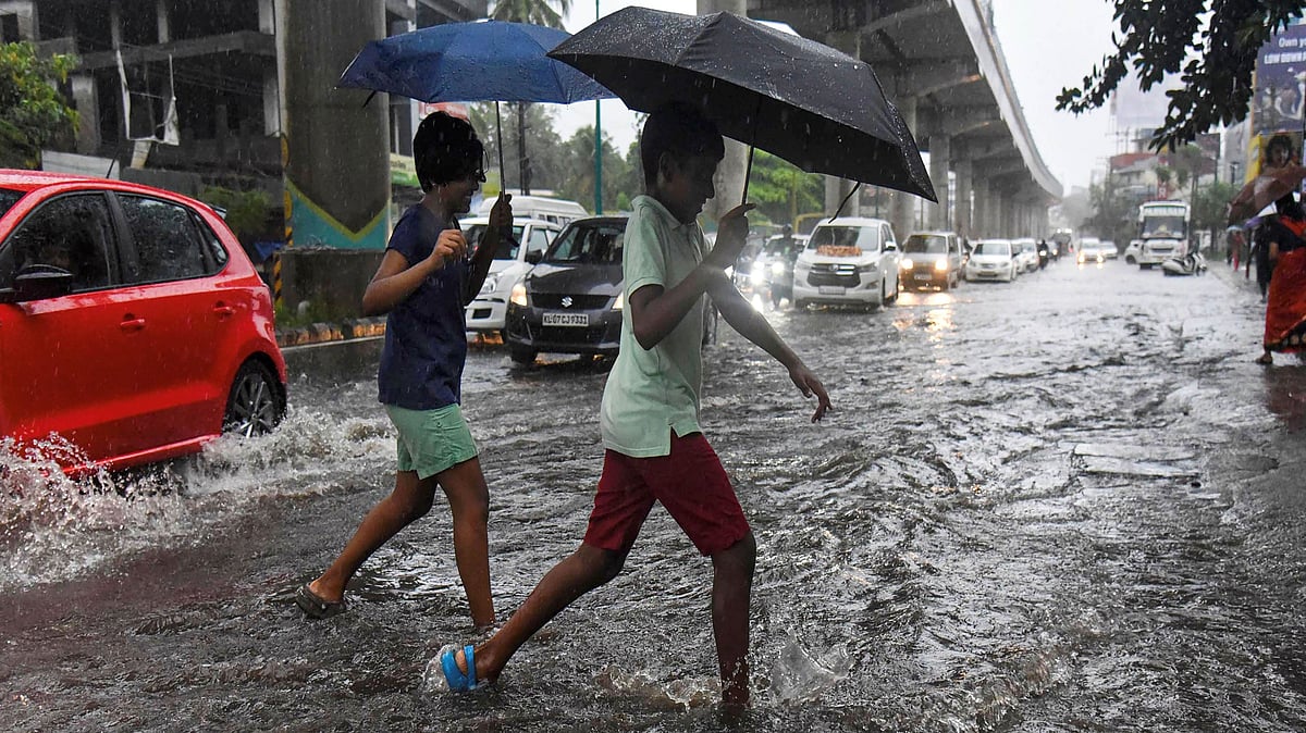
- Monsoon rains lashed parts of Kerala, claiming three lives
- The national capital recorded an all-time high temperature of 48 degrees Celsius
- Churu in Rajasthan was the hottest place in the country at 50.3 degrees Celsius
Western Railway: Seven More Trains Cancelled, 110 Trains Affected
As a precautionary measure in the cyclone prone areas, Western Railway has decided to cancel seven more trains and short terminate with partial cancellation another five trains. A total of 110 trains of Western Railway have been affected.
(Source: ANI)
Cyclone Vayu: Very Likely to Cross Gujarat Coast Between Porbandar and Mahuva
A very severe cyclonic storm, Cyclone Vayu is very likely to cross Gujarat coast between Porbandar and Mahuva on 13 June. More than 2.75 lakh people have been evacuated in the state.
Visuals from the Chowpatty beach in Porbandar.
Guj CM: Over 2.75 Lakh People Evacuated; Army, Navy on Position
On the number of people who have been evacuated, Gujarat chief minster said, “More than 2.75 Lakh people have been evacuated. All sea-related activities have been stopped. All departments are on alert. Senior ministers and senior secretaries have been sent to control rooms of district administration, they're monitoring situation. Planning had been done in advance.”
He further added that 47 troops of NDRF have reached Gujarat, five-six more teams will reach by morning of 13 June. Army, Air Force, Navy, Coast Guard have taken their positions. State Disaster Management is at work and police patrolling will be done throughout the night so that no one is left in the lower regions, he said.
(Source: ANI)
Over Two Lakh People Evacuated from 10 Districts of Gujarat
A total of 2,02,014 people have been evacuated till 6 pm on 12 June from 10 districts of Gujarat.
(Source: ANI)
Cyclone Vayu: Gujarat CM Holds Meeting with Senior Officials
Gujarat Chief Minister Vijay Rupani held a meeting with senior officials of the state, officers from the Army and NDRF and District Magistrates, in Gandhinagar on 12 June. Cyclone Vayu is very likely to cross Gujarat coast between Porbandar and Mahuva as a very severe cyclonic storm on the morning of 13 June.
(Source: ANI)
Cyclone Vayu Turns "Very Severe", Advances Towards Gujarat
Mumbai and some neighbouring coastal areas of Maharashtra witnessed a windy Wednesday, 12 June morning as cyclone 'Vayu' turned into a "very severe cyclonic storm", the Indian Meteorological Department said.
As the cyclone continued to progress towards Saurashtra and Kutch regions of neighbouring Gujarat, the India Meteorological Department (IMD) upgraded its severity condition.
"Cyclone Vayu has turned into a very severe cyclonic storm. It would cause gusty winds to blow at a speed of 145 kmph to 170 kmph by Thursday, 13 June morning," the IMD said.
Partly Cloudy Morning in Delhi, Respite from Heat Likely Later in the Day
It was a partly cloudy Wednesday morning in the national capital, with the minimum temperature settling at 31 degrees Celsius, three notches above the season's average.
Delhiites may get some respite from the oppressive heat as gusty winds and thunderstorm are likely in the later half of the day, a Meteorological Department official said.
‘Very Severe’ Cyclonic Storm Vayu to Hit Gujarat on Wednesday: IMD
Very severe cyclonic storm Vayu over East-central Arabian Sea moved further northwards in the last six hours and lay centered at 2:30 am on 12 June over East-central Arabian Sea, about 450 km west-northwest of Goa, 290 km south-southwest of Mumbai and 380 km nearly south of Veraval in Gujarat, the IMD said.
It is very likely to move nearly northwards and cross Gujarat coast between Porbandar and Mahuva around Veraval and Diu region as a very severe cyclonic storm with wind speed at 140-150 kmph to 165 kmph around morning of 13 June, the MeT department said.
(Source: ANI)
In Lieu of Cyclone Vayu, Gujarat CM Requests Tourists to Go Back
Gujarat Chief Minister Vijay Rupani has requested the tourists who are visiting Gujarat and going to Dwarka, Somnath, Sasan and Kutch, to leave for safer places after the afternoon of 12 June so that the cyclone does not harm them. He further urged to return back, if possible.
(Source: ANI)
South Western Air Command Prepared for Emergencies
The South Western Air Command has proactively enhanced its preparedness to meet any contingencies which may occur due to the cyclone, Wing Commander Puneet Chadha, Defence PRO, Gujarat said.
He further informed that Medium Lift helicopters and Light Utility helicopters have been positioned at nodal points in Gujarat. These are equipped to undertake disaster relief operations. Also, highly mobile deployable radar has been placed at a high state of readiness at Gandhinagar, he stated.
“The radar along with its own satellite communication system can be deployed at remote location for channelising helicopter operations towards relief and evacuation as well as establishing communication with control centers,” he added.
He also mentioned that mobile communication vehicles have been positioned at nodal points and communication support groups have been formulated at air bases in Gujarat to handle potential contingencies.
Cyclone Vayu: Fishermen Advised to Not Enter East-Central Arabian Sea
Fishermen are advised to not venture into sea along and off Gujarat coast from 12 to 15 June. Also, they are advised to not venture into East-central Arabian Sea and along and off Maharashtra Coast on 12 June, northeast Arabian sea between 12-13 June, the IMD said.
Cyclone Vayu: Heavy Rainfall Likely in Saurashtra and South Guj
Heavy to very heavy rains very likely at isolated places in Saurashtra’s Amreli, Bhavnagar, Gir, Somnath, Junagadh and Diu. Heavy rains very likely at isolated places in districts of South Gujarat region namely Surat, Navsari, Valsad, Daman, Dadra Nagar Haveli on 13 June, the IMD said.
Heavy to very heavy rains very likely at isolated places in the districts of Saurashtra-Kutch region namely Rajkot, Jamnagar, Porbandar, Morbi, Dwarka and Kutch on 14 June.
(Source: ANI)
Thunderstorm Prediction in North Gujarat's Districts
Thunderstorm and lightning accompanied with gusty winds at the rate of 40-50 kmph are very likely to occur at isolated places in North Gujarat’s districts namely, Banaskantha and Sabarkantha during 12 and 13 June, the IMD said.
(Source: ANI)
NDRF Positions 39 Rescue Teams, 34 Teams of Army on Standby
The National Disaster Response Force (NDRF) has pre-positioned 39 NDRF teams, comprising about 45 rescuers each, in Gujarat and Diu and they are equipped with boats, tree-cutters and telecom equipment. As many as 34 teams of Army are also on standby.
(Source: PTI)
Thunderstorms at Valsad Coast, Cyclone Vayu Storms Towards Saurashtra
As cyclonic storm intensifies, it culminated into thunderstorms off the coast of Valsad district and is now storming towards Saurashtra’s coast.
Heavy Rainfall Prediction for Goa Due to Cyclone Vayu's Onset
Onset of cyclone "Vayu" will trigger heavy rains in Goa and the Konkan area for the next two days, the IMD said.
The department has issued the "orange" warning for Goa in view of the deep depression over East Central and adjoining South East Arabian sea, which has intensified into cyclonic storm, reported PTI.
Cyclone Vayu Likely to Make Landfall between Veraval and Diu
As high alert has already been sounded in Gujarat ahead of the Cyclonic storm Vayu, the latter is likely to make landfall between Veraval and Diu on the morning of 13 June.
According to IMD, the cyclonic storm was approximately 570 km south of Veraval.
(Source: Twitter)
Heavy Rain Lashes Valsad District
In Gujarat, rain lashes Valsad district ahead of Cyclone Vayu which is expected to make a landfall in Gujarat on 13 June, reports ANI.
Cyclone Vayu Intensifies Into Severe Cyclonic Storm
IMD has said, "It is very likely to move nearly northward and cross the Gujarat coast between Porbandar and Mahuva around Veraval and Diu region as a severe cyclonic storm with wind speed 110-120 kilometres per hour gusting to 135 kilometres per hour during early morning of June 13.”
Guj CM Rupani Cancels 3-Day Festival from 13-15 June
Gujarat Chief Minister Vijay Rupani has cancelled the 3-day Shala Praveshotsav (Welcoming to the school festival) from 13 to 15 June in the entire state.
He has also declared two days holiday on 13 and 14 June in schools and colleges in 10 districts where Cyclone Vayu is likely to impact.
Gujarat CM Vijay Rupani Holds Meeting Ahead of Vayu Cyclone
In Gandhinagar, Gujarat Chief Minister Vijay Rupani held a special meeting with officers on Cyclone Vayu, reports ANI.
Guj & UT Diu to Shift 3 Lakh People from Villages on 12 June
Gujarat and union territory Diu to shift 3 lakh people from low lying areas in coastal villages from the morning of 12 June in the wake of cyclonic storm Vayu, which is likely to make a landfall on 13 June.
(Source: Twitter)
AC-17 Aircraft To Fly Rescue Team to Gujarat From Vijaywada: IAF
Indian Air Force said, “A C-17 aircraft got airborne from New Delhi to Vijayawada, today. The aircraft is planned to airlift about 160 personnel of NDRF from Vijayawada to Jamnagar to carry out Humanitarian Assistance and Disaster Response (HADR) missions for people affected by Cyclone Vayu in Gujarat, reported ANI.
Boulders Installed Along the Ullal Coast in K'Taka After Tense Sea Conditions
In Karnataka, District Administration install boulders along the coast in Ullal in Mangaluru after very rough sea conditions prevail in the region, reports ANI.
Deep Depression in Arabian Sea Intensifies
A deep depression over the Arabian Sea which brewed over the past two days has intensified into a cyclonic storm and is likely to hit the Gujarat coast on the morning of Thursday, 13 June, said IMD.
(Source: PTI)
Fisherman Have Returned, Everyone Alerted: Valsad District Collector
CR Kharsan, Valsad District Collector has said, “Everybody has been alerted in Valsad district, fishermen have come back, people living in coastal villages have also been alerted. District Administration is completely on alert.”
ICG Allows 10 Chinese Vessels to Seek Shelter Under Their Security
Indian Coast Guard Inspector General, KR Suresh said, “10 Chinese vessels seek shelter at the Ratnagiri port (in Maharashtra) to avoid being hit by the fury of Cyclone Vayu. On humanitarian grounds, Indian Coast Guard has allowed them to stay there under security cordon, reports ANI.
Patnaik Meets PM Modi Regarding Special Category Status for Odisha
Naveen Patnaik meets PM Modi, requests special category status for Odisha after Cyclone Fani.
Cyclone Likely to Intensify in the Next 12 Hours
Cyclone Vayu lay centered 350 kms West-Southwest (WSW) of Goa, 510 kms South-Southwest (SSW) of Mumbai & 650 kms South of Veraval, continues to move in Northerly direction and is likely to intensify into Severe Cyclonic Storm in next 12 hours, reports ANI.
HM Amit Shah Chairs High Level Meeting to Review Preparedness Ahead of the Cyclone
Union Home Minister Amit Shah chaired a high level meeting to review the preparedness of State and Central Ministries/Agencies concerned to deal with the situation likely to arise out of Cyclone ‘VAYU.’
It was attended by Home Secretary, Secretary Ministry of Earth Sciences, and senior officers of IMD and MHA.
Vayu Cyclone Likely to Cross Gujarat on 13 June
The Vayu Cyclone is likely to move nearly northward and cross Gujarat coast between Porbandar and Mahuva with wind speed 110-120 km/h gusting to 135 km/h during early morning of 13 June.
'Mumbai Airport Ops Put on Hold Due to Heavy Rains'
“Visibility has gone down due to heavy rains, operations have been put on hold. United Airlines Newark to Mumbai flight has been diverted to Delhi,” news agency ANI quotes Mumbai International Airport Limited (Mumbai Airport) Spokesperson, as saying.
On Heavy Rainfall High Alert, Gujarat Deploys NDRF in Coastal Saurashtra
Gujarat has been put on alert following IMD prediction of the deep depression in the Arabian Sea developing into a severe cyclonic storm and causing heavy rainfall in the coastal areas in the coming days, a senior official said on Monday 10 June.
With the warning of a heavy rainfall in parts of Gujarat, the state government has decided to deploy NDRF personnel in coastal areas of Saurashtra and Kutch from Tuesday morning.
The government will also put the Army, the Navy and the Coast Guard on alert.
The India Meteorological Department (IMD) has issued a warning of heavy rains with winds blowing at the speed of over 110 kms on June 13 and 14 in coastal areas of Saurashtra and Kutch.
(Source: PTI)
Arabian Sea Storms to the Shores of Kannamaly Beach
Pre-Monsoon Showers Hit Nagercoil in Kanyakumari
'Hottest Place in India': Churu in Rajasthan Swelters at 50.3°C
Maximum temperature of 50.3°C was recorded in Churu, Rajasthan on Monday, 10 June, ANI reported, citing India Meteorological Department.
Temperatures in South Bengal Likely to Be Above Normal: MeT
With the Monsoon unlikely to make an entry in West Bengal soon, the Met department on Monday, 10 June, said that day temperatures in South Bengal are likely to be above normal by two to three degrees Celsius.
It said that heat wave condition is "very likely" to prevail over Purulia, Bankura, West Burdwan, Birbhum, West Midnapore and Jhargram districts of West Bengal during the next three days.
Advent of the Monsoon in South Bengal, which occurs normally on 9 June, is likely to be delayed by at least a week.
The Met department said that heavy rain is likely to occur in sub-Himalayan West Bengal districts of Darjeeling, Jalpaiguri, Coochbehar, Alipurduar and Kalimpong districts.
Lack of pre-monsoon showers have led to higher day and night temperature in south Bengal.
(Source: PTI)
Narnaul Bakes at 48.3° Celsius as Heatwave Continues in Punjab, Haryana
Narnaul baked at 48.3 degrees Celsius as severe heatwave swept Punjab and Haryana on Monday, 10 June.
The temperature in Narnaul town of Haryana was seven degrees above normal and recorded the season's hottest day so far, the meteorological department said.
Bhiwani and Hisar recorded maximum temperatures of 46.8 degrees and 46.4 degrees Celsius, respectively, up five notches each against normal.
Ambala and Karnal also sizzled under maximum temperatures of 44.8 degrees and 44.4 degrees Celsius, respectively, six and seven notches above normal.
Scorching heatwave swept Chandigarh, which recorded a maximum temperature of 44.1 degrees Celsius, up five notches against normal.
In Punjab, the maximum temperature in Amritsar was 45.2 degrees Celsius, six degrees above normal.
The maximum temperatures in Ludhiana and Patiala were seven notches above normal at 45.5 degrees and 45.8 degrees Celsius, respectively.
The heatwave conditions are likely to continue in the two states over the next two days, according to the weather department's forecast.
(Source: PTI)
Heatwave to Prevail in Isolated Places of Telangana
The India Meteorological Department (IMD) has issued a warning that heatwave conditions are very likely to prevail at isolated pockets in different districts of Telangana till 12 June.
Adilabad district on Monday, 10 June, recorded the highest maximum temperature of 44.3 degree Celsius in Telangana.
After Adilabad, Ramagundam recorded 43.4 degree Celsius while Hyderabad recorded 38.7 degree Celsius.
Parts of Telangana have been experiencing heatwave for over a month with the mercury crossing the 40 degree Celsius mark in several places.
(Source: PTI)
3 Killed as Rains Lash Kerala on Day 3 of Monsoon
Monsoon rains lashed parts of Kerala, claiming three lives while a depression in the Arabian sea intensified into a deep depression on Monday, 10 June, police and the weather department said.
Two of the victims, including a woman, were electrocuted on a water-logged road in Thiruvananthapuram while a man died and two others were injured when a tree fell on them in Kochi, police said.
The India Meteorological Department (IMD) said the depression in the Arabian Sea moved north-northwestwards with a speed of about 15 kmph in last six hours and intensified into a deep depression and is very likely to intensify further into a cyclonic storm during next 24 hours.
The fishermen have been warned not to venture into sea for next two days as it was likely to be rough.
(Source: PTI)
11 Places in Odisha Record Temperature Above 40° Celsius
Heat wave condition remained unabated in Odisha, particularly in the western region, with the temperature soaring above 40 degree Celsius in at least 11 places on Monday, 10 June.
Coastal and interior areas of the state also reeled under unbearable weather conditions due to rising temperature coupled with high level of relative humidity.
Hirakud in western Odisha turned out to be the hottest place in the state recording 44.8 degree Celsius followed by 44.6 degree in neighbouring Sambalpur, the Meteorological Centre said.
The mercury touched 43.6 degree Celsius in Titlagarh, while it was 43.2 degree in Jharsuguda, 42.5 degree in Bolangir, 41.8 degree in Sonepur, 41.1 degree in Angul, 40.5 degree in Talcher, 40.4 degree in Phulbani, 40.2 degree in Bhawanipatna and 40 degree in Sundargarh.
The state capital Bhubaneswar recorded a maximum temperature of 37.8 degree Celsius with relative humidity of 82 percent.
(Source: PTI)
Delhi Records All-Time High Temperature at 48° Celsius
Temperature soared at an all-time high of 48 degree Celsius in Palam, Delhi on Monday 10 June, ANI reported, citing Indian Meteorological Department.
The city's previous high of 47.8 degrees Celsius was recorded in Palam on 9 June, 2014.
"The Palam Observatory recorded an all-time high of 48 degrees Celsius Monday. The factors that led to this are dry westerly winds, no effect of a western disturbance in the plains and intense heating in the month of June," reported PTI, quoting IMD regional weather forecasting chief Kuldeep Srivastava.
"Southwesterly winds on Tuesday may cause the temperature to drop by one or two notches. However, the heat wave will persist," Srivastava reportedly said.
Similipal Tiger Reserve to Remain Closed from 16 June Due to Monsoon
The Similipal Tiger Reserve (STR) in Odisha's Mayurbhanj district will remain closed to tourists from 16 June in view of the monsoons, officials told PTI on Monday, 10 June.
The date of reopening of the STR and sanctuary will be notified later after the monsoon ends, a press release issued by STR authorities said.
The closure of the tiger reserve from mid June to October end every year is a routine affair as road communication gets disrupted due to rains.
Rain & Hailstorm Lash Parts of Maharashtra's Aurangabad
A Year After Century’s Worst Floods, Kerala Releases Monsoon Preparedness Guidelines
In order to coordinate relief and rescue programmes during both the southwest and northeast monsoon seasons, Kerala disaster management authority has compiled a new handbook detailing monsoon preparedness guidelines, the Indian Express reported on Monday, 10 June, quoting officials.
The handbook, a first-of-its-kind, details responsibilities of each government department during the monsoon seasons, the report said, adding that the State Emergency Operations Centre, district-level units of the disaster management along with various government departments will work closely during such crises.
The Kerala Dam Safety Authority has also been asked to submit to the government a safety assessment report the of all dams in the state before the arrival of annual rains, it said.
Nagpur Municipal Corporation Fails to Make City Monsoon Ready: Report
Despite facing serious problems last year, the Nagpur Municipal Corporation has not undertaken works to prevent water logging and road mishaps during monsoon, the Times of India reported on Monday, 10 June.
A large number of potholes on roads, choked storm water drains, improper restoration of trenches, open manholes, power cables on the surface layer, incomplete cement roads, flyover works etc are likely to make monsoon miserable for citizens.
The situation is worse on major roads proposed for concretisation and flyovers, including Orange City Street, Khamla Road, Inner Ring Road, Central Avenue, Old Bhandara Road etc.
Gujarat Likely to Get Heavy Rain Due to Cyclonic Storm
A heavy rainfall warning has been issued in parts of Gujarat in the next few days due to a depression in the Arabian Sea which is likely to turn into a severe cyclonic storm, a MeT official said on Monday, 10 June.
Fishermen have been advised not to venture into the sea in the next few days and ports have been asked to flag the danger signal, he said.
"Heavy rain warning has been issued for Saurashtra and Kutch on June 13 and 14 due to the depression in the Arabian Sea which will turn into a severe cyclonic storm," state meteorological director Jayanta Sarkar told reporters here.
The depression over south-east, adjoining Lakshadweep and east-central Arabian Sea moved northwards with a speed of about 31 kmph on Monday.
Deep Depression to Intensify Over Arabian Sea: MeT
MeT Department on Monday said, depression over Southeast Arabian Sea located near latitude 12.5°N and longitude 71.0°E over is about 240 km northwest of Aminidivi (Lakshadweep), reported ANI. It will intensify into a deep depression in next 6 hours, into a cyclonic storm in the subsequent 24 hours, said the department.
Warm Morning in Delhi, Heatwave to Continue Throughout Day
It was a warm morning in the national capital as the minimum temperature settled at 27.2 degrees Celsius, a notch below the season's average, on Monday, 10 June.
Heatwave will continue during the day and the maximum temperature is expected to settle at 43 degrees Celsius, according to the MeT department.
The weatherman has predicted clear skies and said there is no possibility of any respite from heatwave in the next few days.
Monsoon Likely to Be Delayed in Odisha
Southwest monsoon, that hit Kerala after a week-long delay on Saturday, 10 June, is likely to make a late arrival in Odisha, the IMD's regional centre said, reported PTI.
The monsoon is unlikely to hit Odisha in the next four-five days and no specific date has been announced about its arrival, H R Biswas, Director of the Meteorological Centre in Odisha said.
The monsoon usually makes an onset in Odisha by June 10, he said.
"At present, there is no sign of the onset of monsoon in Odisha and a clear picture is likely to emerge in a day or two," he said.
Pre-monsoon Showers Hit Hilly Region in Maha
Pre-monsoon showers hit hilly regions of Maharashtra's Satara district on Sunday slowing down traffic on National Highway 4 connecting Mumbai to Bengaluru, officials said.
IMD officials said some parts of Aurangabad and Jalna received showers accompanied by thunderstorms in the evening, adding that Pune, especially Baramati and Indapur towns, also experienced rain and lightning.
Shirdi in Ahmednagar district received heavy showers along with gusty winds and lightning.
North, Central India Reel Under Heatwave
There was no relief from the heatwave conditions in north and central regions of India even as monsoon advanced in the southern state of Kerala on Sunday.
The national capital reeled under scorching conditions as the maximum temperature settled at 43.8 degrees Celsius, four notches above the season's average. The IMD has forecast heatwave conditions for Monday as well in the city with clear skies.
The weatherman has warned that heatwave conditions will prevail in north and central India next week, and predicted “severe heatwave” in Punjab, Haryana, Uttar Pradesh and Rajasthan over the next two days.
Churu Remains One of The Hottest Regions
On Sunday, Sri Ganganagar in western Rajasthan was the hottest place in the country at 48.5 degrees Celsius, while Churu and Kota districts of the state followed close behind, recording a maximum temperature of 48.3 degrees Celsius each.
Heatwave conditions continued in Punjab and Haryana as Narnaul (Haryana) settled at 47 degrees, four notches above normal limits, while Bhiwani and Hisar also sizzled at 45.9 degrees Celsius and 45.3 degrees Celsius, respectively.
Chandigarh, the joint capital of the two states, recorded a maximum temperature of 42.7 degrees Celsius.
Dry Weather Prevails in UP, Jammu Reeled Under Heatwave
In Punjab, Amritsar recorded a hot day at 44 degrees Celsius, four notches above normal. Ludhiana and Patiala also recorded four notches above normal maximum temperature at 44 degrees Celsius and 44.4 degrees Celsius, respectively.
Dry weather conditions prevailed in Uttar Pradesh with state capital Lucknow recording a maximum temperature of 43.1 degrees Celsius, three degrees above normal.
Allahabad was the hottest city in the state, where the mercury settled at 47.7 degrees Celsius, seven notches above the normal. Kanpur recorded a high of 45.1 degrees Celsius, while in Varanasi it was 45 degrees Celsius.
Jammu reeled under heatwave conditions, recording a high of 43.1 degrees Celsius, while in the hill state of Himachal Pradesh heatwave conditions prevailed, despite rains in isolated parts in the Saturday evening.
Kalpa received 4 mm rain, followed by Dalhousie at 3 mm, Kufri at 1 mm and Bhuntar at 0.6 mm.
Una continued to be the hottest place in the state with maximum temperature of 43.2 degrees Celsius.
Monsoon Catches Up in Kerala
Several parts of Kerala received moderate rainfall on Sunday, a day after the southwest monsoon set in over the state, even as a low pressure area formed over the Arabian Sea.
The Meteorological Department said the low pressure was expected to intensify into a depression in the next two days and subsequently, into a cyclone.
Forecasting isolated heavy rainfall and squally weather in coastal areas of the state and in Lakshadweep islands, it advised fishermen not to venture into the sea till 13 June.
A bulletin issued by the department at 3 pm said the low pressure area has formed over the southeast Arabian Sea and adjoining Lakshadweep area and the east-central Arabian Sea under the influence of the cyclone circulation.
"It is very likely to concentrate into a depression during the next 48 hours over southeast and the adjoining east-central Arabian Sea. It is very likely to move north-north-westwards and intensify further into a cyclonic storm subsequently," it said.
Delay in Monsoon Pushes Rainfall Deficiency to 45% in First 9 Days of June
A delay in the arrival of monsoon has pushed the country's rainfall deficiency in the first nine days of June to 45 percent, the India Meteorological Department (IMD) said.
Monsoon made an onset over Kerala on 8 June, a week after its normal arrival date. This has also delayed its arrival in different parts of the country.
The rainfall deficiency in June could be higher due to the sluggish pace of the monsoon and a weak El-Nino, a phenomenon associated with heating of Pacific waters.
An on-going cyclonic circulation in the Arabian Sea could slow down the progress of monsoon over the next few days, it said.
Of the four meteorological divisions of the country, the deficiency was 66 per cent --- the highest in the country --- in central India that covers the states of Maharashtra, Madhya Pradesh, Gujarat, Goa, Odisha and Chhattisgarh.
(With inputs from PTI)