Balakot Strikes Missed, Targeting Error Possible Cause: Aus Report
According to a report by Australian Strategic Policy Institute, “a systematic targeting error” led to missed targets
advertisement
Amid India’s claims and Pakistan’s counter-claims on the efficacy and potency of the air strikes conducted by the Indian Air Force in PoK’s Balakot, a new report based on high-resolution satellite imagery claims that the intended targets – JeM terror camps – were not ‘visibly damaged’.
The report, by Australian Strategic Policy Institute (ASPI), claims that publicly available satellite imagery acquired by European Space Imaging the day after the strike suggests that buildings at the camp were not “visibly damaged or destroyed”.
The report also claims that the damage (or lack thereof) is not “consistent with either a SPICE 2000 strike or a strike with other munitions”.
“We believe that even a weapon with reduced explosive fill would cause damage to buildings that would be identifiable in the satellite imagery,” the authors of the report claim.
The Balakot air strikes have been at the centre of a political storm in India, with several leaders of the ruling dispensation claiming that the air strikes had inflicted ‘serious damage’ on the JeM campsites, leading to anywhere from 200 to 400 casualties.
The IAF, meanwhile, has refused to disclose a head count but confirmed that “all intended targets had been hit”.
Targets Missed by ‘Similar Distances'
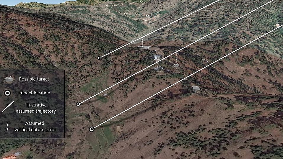
Another striking claim made by the report was that, as per the high-resolution images, all three weapon strikes missed their intended targets by similar distances. They all also missed in the same direction.
This error was likely caused in a scenario in which the Indian Air Force opted to rely solely on the weapon’s ‘set and forget’ GPS capabilities, they said.
“One explanation for the miss is that the SPICE 2000 bombs were incorrectly programmed to fly precisely into GPS points that were, say, 33 metres above their intended targets (the buildings on top of the ridge line). They performed as programmed and then continued on their trajectories until they struck the valley beneath,” the report said.
“The image (above) correlates the identified impact sites, the buildings that were the likely targets and a discrepancy between ellipsoidal and orthometric height which we have assumed to equate to 33 metres above the target buildings. Presented in 3D, this correlation results in consistent, parallel trajectories indicating a consistent targeting error,” it added.
Another possible explanation for the weapons ‘missing’ their targets was the inter-operational frailties of using French jets, Israeli weapons, US GPS and a targeting system that potentially used maps based on an older local Indian datum, the report said.
‘Analysis Based on Illogical Assumptions'
Colonel Vinayak Bhat (Retd), a military intelligence veteran of the Indian Army, however, argues in his piece for The Print that the Australian researchers were "picking imaginary holes" in the IAF’s air strikes on Balakot.
The IAF would have most certainly calibrated its systems and practised such strikes many times in various environment, he argues.
Another point that goes against the ASPI authors, as per Bhat, is that the “guidance system of the bombs used in this operation is not only based on GPS coordinates, but also on aerial photos and satellite images.”
This, he said, increases redundancy, and thus increases the hit probability.
Another striking counter-claim made by Bhat is regarding the direction of fire.
ASPI analysis claims that the weapons were fired from 197º to 240º. This means, as per Bhat, that the IAF aircraft would have to have been much within Pakistan’s territory.
“The three directions of fire the researchers propose, when plotted on Google Earth, would mean that the distance between the first and third aircraft was almost 45 km — which is impossible,” Bhat wrote.
(With inputs from Australian Strategic Policy Institute, The Print)