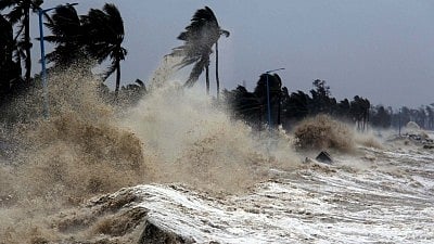
Global Sea Levels Higher Than Estimated, Raising Risks of Coastal Floods: Study
The findings indicate that earlier research and planning underestimated the baseline height of coastal waters.
advertisement
Recent scientific analyses indicate that global sea levels are significantly higher than previously estimated, placing millions more people at risk of coastal flooding and related hazards.
The findings indicate that earlier research and planning underestimated the baseline height of coastal waters, particularly in regions across the Global South, Pacific, and Southeast Asia.
According to The Hindu, a comprehensive study published on 5 March 2026 in the journal Nature reviewed hundreds of scientific papers and hazard assessments, revealing that approximately 90 percent of them underestimated baseline coastal water heights by an average of 30 centimetres.
This discrepancy is attributed to a mismatch in the methods used to measure sea and land altitudes, leading to a “methodological blind spot” at the intersection of water and land.
As highlighted by The Guardian, the research suggests that ocean levels are far higher than previously understood due to inaccurate modelling.
The study found that many assessments assumed a “zero-metre” starting point for sea level, failing to account for dynamic factors such as waves, tides, and currents that affect actual water heights at the coastline.
Midway through the study, researchers noted that adjusting to a more accurate coastal height baseline could mean that if seas rise by just over one metre by the end of the century, up to 37 percent more land could be inundated, threatening an additional 77 million to 132 million people.
The analysis showed that the risk is especially acute in Southeast Asia, where population density along vulnerable coastlines is high.
Outside experts cited in the study emphasised the practical implications for disaster planning and adaptation.
“You have a lot of people here for whom the risk of extreme flooding is much higher than people thought,” said Anders Levermann, a climate scientist at the Potsdam Institute for Climate Impacts Research.
“Sea level rise is not just changing our coastline, it's changing our lives. We are not talking about the future — we're talking about the right now,” stated climate advocate Thompson Natuoivi, reflecting the immediate impact on communities in the Pacific.
Further, coverage revealed that the methodological oversight is less common in Europe and along Atlantic coasts, where local planners often have more accurate elevation data.
However, in the Indo-Pacific, the baseline error can approach one metre, significantly increasing the projected impact of sea level rise.
In practical terms, reporting indicated that governments and planners may be preparing for coastal and climate risks with incomplete information, potentially underestimating the resources needed for adaptation and mitigation.
The study’s authors recommend revising hazard assessments and planning models to incorporate more accurate baseline measurements.
Real-world examples from the Pacific islands illustrate the urgency of the issue. On Vanuatu’s Ambae island, for instance, coastal roads have been rerouted and graves submerged due to encroaching waters.
As details emerged, local communities are already experiencing the consequences of underestimated sea levels, with some homes now less than one metre from the sea at high tide.
Experts caution that while some local planners are aware of their region’s specific risks, the widespread underestimation in global models could hinder effective responses elsewhere.
Findings suggest that improved measurement techniques and updated models are essential for accurately assessing and addressing the growing threat of sea level rise worldwide.
Note: This article is produced using AI-assisted tools and is based on publicly available information. It has been reviewed by The Quint's editorial team before publishing.